
(This is the Lesson Plan 1 for Carol Buswell’s curriculum unit, “Exploring Your Community.”)
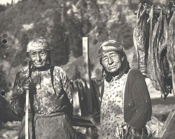
Alice Slim Jim Charley and her sister Liza, who married a Warm… Springs Indian and is listed on their roll. Liza Comes Back to camp with Alice [to]…fish at the Mouth of the White Salmon River, 1952. (National Archives: Department of the Army. Office of the Chief of Engineers.)
American Indians are both individuals and members of a tribal group.
Native Knowledge 360°: Framework for Essential Understandings about American Indians, National Museum of the American Indian, 2015.
APPLICABLE COMMON CORE STATE STANDARDS
Grade 4
- W.4.8: Report on a topic or text, tell a story, or recount an experience in an organized manner.
- SL.4.4: Recall relevant information from experiences or gather relevant information from print and digital sources.
Grade 5
- W.5.8: Report on a topic or text or present an opinion, sequencing ideas logically and using appropriate facts and relevant, descriptive details to support main ideas or themes; speak clearly at an understandable pace.
- SL.5.4: Recall relevant information from experiences or gather relevant information from print and digital sources; summarize or paraphrase information in notes and finished work, and provide a list of sources.
ENTRY QUESTIONS
- Who am I?
- Where did I come from?
- Where do I live?
- Who is in my family?
- Where did my ancestors come from?
- What do I already know about my community, my area, my state, my country?
- What can the experiences of Lewis and Clark and the Native Americans along the trail teach me about doing research?
LEARNING OBJECTIVES
The students will learn the most basic elements of a primary source, write their own firstperson narrative, and be introduced to various digital resources related to the Lewis and Clark journey.
MATERIALS AND RESOURCES
For a complete listing of all materials necessary for the entire curriculum by episode, see Curriculum Materials and Resources at a Glance
Materials
- A journal for each child containing at least 60 blank pages.
- A large topographic map of the United States.
- A largescale map of your own community, showing streets and (if possible) buildings, such as a screen print of a Google Map showing the topographical map layer and the street name layer.
- Alternatively, you may want students to work independently to locate their home on Google Maps, then use an interactive program with the group such as Google Earth Tour Builder, where each of the students’ homes is represented in the tour.
- Posters (2) consisting of very simplified definitions of primary and secondary sources. These can be enlarged for classroom use, if desired. (see Appendix)
12Google Earth Tour Builder
Resources
Websites (all will be used for this and for future episodes)
- National Park Service: Lewis and Clark Tribal Legacy Project
- Library of Congress: Fill Up the Canvas
- Lewis and Clark Journals
SUGGESTED LESSON DEVELOPMENT
Before Class
Post the following in the classroom in a place where they can be easily seen and leave them up for the entire unit (two weeks).
- A topographic map of the United States
- A largescale map of your own community, showing streets and (if possible) buildings, such as a screen print of a Google Map showing the topographical map layer and the street name layer (if you are going to use Google Earth Tour Builder spend some time using the program and adapting to it to produce a map that can be posted in the classroom after this lesson is over)
- The simplified definition of a primary source: A depiction of an event written or told by someone who was there at the time (usually a first-person account)
- The simplified definition of a secondary source: A depiction of an event or events created by someone who has examined source evidence and come to his or her own conclusions (usually a third-person account)
Introduction
This episode is intended to introduce students to primary sources. Records of Lewis and Clark and the stories told by Native Americans along the Trail are used as models for student work.
Lesson Development
- Tell the students they are going to learn to become explorers, like Lewis and Clark. Tell them they will be exploring their own community.
- Show the students the material placed in the classroom: the topographic map, large scale map, and definitions of a primary and a secondary source. Explain that Lewis and Clark had maps to follow when they went on their journey. Tell them a little about the Lewis and Clark story.
- Tell the students that Lewis and Clark created “primary sources” as they traveled along the trail, because they were actually there and had information they had gathered and seen for themselves. Read the definition of a primary source with the students. Explain that primary sources are very important because they get us as close as possible to actual events.
The point of view of members of the Lewis and Clark expedition
- Introduce the Lewis and Clark map.
- Review the route on the map with the students.
- Note some of the numbered items.
- Click on #3, “First Council with the Indians.”
- Have them read the text or read it to them.
- Explain that there were many tribes who were not related to each other living along the trail.
- Point out the portion of the Lewis journal text that says “asked [for] our mediation between themselves and the Maha, with whom they are now at war.” Explain what mediation was and how tribes were sometimes at war with one another.
- Point out that Lewis wrote this in his journal. His journal is a primary source because he wrote down what he saw and heard. He was there in person, at the time of the event.
- Show an actual Lewis and Clark Journal page as an example. (Lewis and Clark Journals)
Point of view of various American Indians
- Introduce the Tribal Legacy map.
- Point out or ask the students to point out where the Oto-Missouria and other tribes lived on the interactive map by passing the cursor over the locations.
- Note how the boundaries are blurred and sometimes overlap. Explain that Native people did not put up fences or draw lines around their territory.
- Explain that some of the Native people who were living along the Lewis and Clark Trail still have descendants who are living in nearly the same place as their ancestors were during the Lewis and Clark period. By using the online map it is possible to listen to these descendants speak to us and tell stories about each of their communities.
- Point out where the Mandan and Hidatsa territory once was on the map. Tell the students you are going to listen to someone from that tribe.
- Listen to Gerard Baker (Mandan and Hidatsa) telling about his experience as a National Park Ranger. Ask the following questions. Did Gerard Baker live during the time of Lewis and Clark? (They may not know…point out the microphone and the stage as evidence of modern times.)
- Is this man a Native American? How can you tell? (Visual cues, such as hair and costume. Perhaps one could also discuss here how we have to guard against stereotyping people based on such cues.)
- Where do you think he works? (Explore his experience in the Park Service.)
- What does he want to happen to you when you visit the Park? (He wants us to leave the Park with more questions than answers.) Why do you think he wants you to have questions?
- Is he excited? How can you tell? (He uses his arms and voice to show expression.)
- Tell the students that this video is a primary source. Gerard Baker is talking about his own experience with the Park Service, so he is relating something he participated in. He was there at the time of the Bicentennial. (When he talks about the Lewis and Clark expedition, however, his comments would be considered a secondary source, because he was not there at the time.) Primary sources can be in many different forms such as written documents (like Meriwether Lewis’s journal entry), photographs, or audio and videotapes.
Student Activity
- Ask each student to mark their own home on the large scale map of their community using a map pin or by drawing a circle around it (or use Google Maps, Google Earth Tool Builder or a similar computer program).
- Ask each student to create a “primary source” by writing a short description of how they got to school that morning in their journal. What route did they take? What happened along the way? What part of the neighborhood did they pass through? Explain that they must have seen or experienced this themselves.
- Have them illustrate their writing with a drawing depicting an event or the places they saw along the way.
- If there is time, have some of the students pantomime or speak about one of their experiences using facial and body expressions. Each student should take no more than a few seconds each.
- Both the writings and the pictures will be used at a later time.
VOCABULARY
Review these words briefly with your students and explain further if necessary (see Glossary).
- depiction
- primary source
- secondary source
- first-person
- third-person
DIFFERENTIATED INSTRUCTION (FOR ADVANCED AND EMERGING LEARNERS)
Emerging learners may need to have some of the primary source material read to them or paraphrased. Instead of writing their experiences, they might record them on audio tape or video, just as Gerard Baker did.
Advanced students may be interested in completing the “Lewis and Clark in the Complex West” DocsTeach activity in order to gain some more experience with primary sources.
SUGGESTED FORMATIVE ASSESSMENT OF LEARNING OUTCOMES
Teachers might develop a small “observation notebook” and take notes as they circulate through the classroom in order to keep track of which students may need the most assistance either at the time or in the future.
- Observe students as they are writing and help them to understand the concept of a “primary source” where needed.
- Question the students during the online portion to see if they can see the relationship between the tribal examples and the exploration of their own community.
- Observe the students as they locate their home on a map to see if they understand basic map symbols and concepts.