By Bob Parker
CPW made the local news today for our work with Friends of the Old McKenzie Hatchery (Friends) on the McKenzie Interpretive Center concept. The article, published in the Register-Guard, discusses Friend’s plans for the Old McKenzie Hatchery site.
The McKenzie River is a national treasure. It has a storied history that is far to deep to delve into here. One of the signatures of the McKenzie is the McKenzie Drift Boat. The boat designs have now been exported all over the world. The idea of a drift boat museum has been floating around for some time now, but has never reached critical mass.

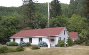
The Old McKenzie Fish Hatchery was built in 1903 and is part of the River’s heritage. The hatchery operated from 1903 through 1952. was in operation until 1952 when it became less economical in its production. The hatchery system, a series of channels and ponds, are still intact, but are being infilled by vegetation. Ultimately, the Oregon Department of Fish and Wildlife needed more capacity and moved the hatchery across the river to a larger site. The Old McKenzie Fish Hatchery has several unique buildings and currently serves as a rest stop for visitors.
The river also led to the development of the McKenzie drift boat—watercraft that are uniquely designed for rivers. The McKenzie drift boat design has been adopted internationally and is common among river watercraft. The concept of a McKenzie Drift Boat Museum has been around for some time. The McKenzie Interpretive Center would also provide a permanent location for the Museum.
 Recognizing the Old McKenzie Fish Hatchery was an underutilized asset, in 1986 Lane County commissioned a study by the Community Planning Workshop to evaluate potential uses of the site. The study ultimately concluded that a campground would be a viable use economically and that the forested portions of the site required management. No action occurred as a result of the 1986 study. The site housed the McKenzie River Chamber of Commerce for a number of years. The Chamber ceased operations on the site in the 1990s. Since that time, the County has leased the residence and has struggled to keep up with maintenance of the historic buildings on the site.
In 2015, representatives of Friends approached the CSC about helping with a feasibility study for the proposed interpretive center. Notably, CPW completed a study of potential uses of the Old McKenzie Hatchery site in 1986. At that point, the study identified managing the site for timber as a potential option. The County maintained ownership of the site for the 40 years since the study, but was still exploring opportunities for the site.
The Friends of Old McKenzie Fish Hatchery (Friends) are pursuing a concept to create a showcase for McKenzie River riverboats and their guides at the Old McKenzie Fish Hatchery (OMFH) near Leaburg Dam on Highway 126. Over the past several years, Friends has spearheaded an effort to develop an interpretive plan, exhibit concepts, a capital improvements budget, and an architectural program for the proposed facilities, which are tentatively called the McKenzie River Interpretive Center. The concept divides the river’s stories into three categories, later named “Story Zones.” These zones are:
- Zone One – Boats & Guides

Roy Pruitt - Zone Two – River & Watershed
- Zone Three – Fish & Ecology
The Friends of Old McKenzie Fish Hatchery (Friends), a 501(c)(3) entity formed for the purpose of furthering recreation and education at the OMFH, is coordinating the effort which includes several partners. Moreover, Lane County Parks Department owns the the structures and associated adjacent land is expected to lease the site to The Friends for ninety-nine years. The western portion of the site is listed on the National Registry of Historic Places because it houses the original hatchery, and therefore comes with certain restrictions, Lane County is expected to make the eastern portion available for new construction.
In short, this is a very exciting opportunity to build a world-class facility on a significant historic site. We are honored to be a part of this exciting project and to provide advice to the Friends.


