
SKILLS
GIS VIZ TOOL (ELK + CSV)
– to understand social and ecological conditions of place.
Ladybug
– 3 d parti, wind rose and sun rose
+Traditional Urban Design site analysis
– infrastructure
– sociological methods: observations; interviews; socio grams from public
– urban section, plan
PROJECT OBJECTIVES
Site location: Barcelona
– Edge Eixample and possible relate to previously autonomous village (forthcoming Superilles: Horta, Sarria, etc)
– Urban ideas: how to reflect place, urban problems or solutions, Covid 19
Program: Street and intersection that connects the inhabitants of Barcelona.
We will try to present these ideas to the experts in Digital Art, Computer Science, Inclusive Urbanism, Time and Nature, Landscape Architecture
Affect human behavior (theory of interaction) people must engage.
You will work in teams of two.
SCHEDULE
Week 1
Monday
Introduction and feedback
- Cars in spaces through 1970’s and 80’s, merce. Why cars and how’s took over. Big 3 bought street car lines. buses. EPA. Sustainability. Walkability. Moses vs Jacobs.
- Barcelona Urbanism history: 1975, Franco, Catalán identity, Bohigas lapiz de oro, Olympics (10x rondas), hard vs softscape plazas. Village feeling in Spain. Example cerda
- Urban Ecology: McHarg, Guallart, Rueda, Margalef: Agency of Urban Ecology
- Shared streets examples from Philip
- Superilles in Barcelona: 0) Gracia; 1) Poblenou; 2) San Antonio; 3) Horta
Get to know each other
Wednesday
Barcelona Urban Design History: Cerda Grid 1864
Superillas- 1) Superblocks: How Barcelona is taking city streets back from cars by David Roberts
- Air pollution (PM and NO) and Sound Quality (existing maps, live)
Superilles, la Barcelona que ve
[Software Skills]: Rhino Grasshopper tutorial , GH warmup tiling Cerda Barcelona
*Supplemental Rhino/Grasshopper tutorial: fundamentals, Rhino vs Grasshopper geometry, point attractor, image sampler, data tree intro, (Weekly: Thursdays, 8pm)
Assignments:
- Writing: Make a post paragraph writing one sentence about each 1) what, 2) who it affects and 3) why it is important about:
- 2 of the following research areas: Barcelona Smart Cities, citizen sensors iaac, Sentilo, Shush. [post category: research 1]
- 3 shared Streets: 1) USA; 2) Europe (woonerfs); 3) Asia; 4) South America or Africa; 5) Australia
- Readings related to lecture: Maritime Metropolis Pueblos, Eixample, 22@ and Superilles. [R: Sola-Morales, Guallart and Rueda]
- Grasshopper (GH) Workshop: Block-Unit Tiling of formal and non-formal parameters, etc (Block/street tiling exercise of Eixample [A2: Eixample – Post-processing: 3 Series of 3 x 3 units at size 2″ x 2″, line weights, outlines, 1 highlight color, use Rhino and or Grasshopper – Example 2016 + Chaz]
- [R: Journal of Urban Design: Systematic, Experiential and Open by Speranza]
W2 Key database, virtual site visits, site documentation, place documentation.
Monday
Review 1) Eixample block exercise, 2) Writing and 3) Shared Street examples
Discuss shared Street of Superilles: Questions (forthcoming J. of Urban Design)- 1) Tactical vs strategic; 2) systematic vs isolated pilot; 3)model adaptation around Barcelona. [Google Street View of San Antoni Superills + Poblenou Superilla. Horta / Sarria?]
Review site together, Eixample but perimeter; Poblenou school is ideas situation.
Assignment: Students identify problem [post category: Research 2]
- Paragraph 1. Shared Streets: What problem; who affects; why important
- Paragraph 2. Specific problem in Barcelona; qualities to measure; What method to start to study; research question related to method.
- Post Site research: Infographics. Social and Climate data. Get to know site intimately. Deep research. Other than Google Street View and Yelp. Twitter? Grasshopper for Twitter? Catchup on blog posts. [Reading: “Social Interaction and Cohesion Tool: Integrating Socio-Computational Design in Urban Ecology for Barcelona’s Superilles”]
[Skills]: Elk [OpenStreetMap]
Wednesday
1.1 Design: Social interaction tool; 1 pilot block / street data collect; Design Method Overview: 1) Urban Design – human scale; 2) Indicators, theory, qualities; 3) Rating systems (Walk Score)
Diagram Theory- Structure data by: big ideas, sub-ideas, qualities, indicators (public private, etc)
3.0 Project book (Chaz example and posters later): project description and initial site documentation due with reference to 3 readings and 2 precedents.* Due Monday 8/10, 10%
Match making?? Research 2: get into groups?
[reading: “Atmosphere InFormed“]
[Skills]: GIS VIZ TOOL Social interaction tool [CSV mapping] z-line, heat map, tags, circles; Google Maps: drop pins; export; and convert
W3
Monday
3.1 Mapping exercise (remotely): Map a street with ratings via Google Streetview; small scale; catastral? Eixample Dreta Superilla (NS Gran Via and Arago + San Joan and Sicilia) / Sarria Superilla
3.2 Street design Presentation (Jesus at Aldayjover): Design elements or diagrams for tactical manual; 3D parti diagrams (SA+UD, Studio Gang) Passeig San Joan
3.3 Project book (Chaz example and posters later) [blog post: 1.0 Project Book]:
- 1) Project description (2 paragraphs)
- 2) Infographics on the problem. Related climactic and or Social data.
- 3) Diagram of: Big Idea; Sub ideas (social + environment); qualities; indicators (you can start custom icons for each indicator)
- 4) Neighborhood map 8 x 8 blocks (main streets, parks, Diagonal, with labels,
- 5) Data maps of each (ELK / GIS vis tool of 4 data types, minimum)
- 6) 3 theoretical citations (of any reading from class/blog article) photo collage silhouette
- 7) 2 shared streets precedents (1 max in Europe)
Due Monday 8/10, 10%
[Skills: Ladybug- graphs of temp, humidity and rain; psychometric charts; sun path; radiance, wind rose] https://blogs.uoregon.edu/222s20/lab-notes/week-8-gh-ladybug/
Wednesday
MAPPING
LADYBUG
QUICK CHECK-IN WITH EACH GROUP
Urban Design: Map together – each person has 2-3 data types to rate
108 point Map. 6-8 maps individually.
Graphic Design: Scales of time across: day, week, season and year.
Weather Phenomena, landscape and animal timeline Presentation (Minard, Field Operations, SA+UD)
[Skills: Ladybug (Diva template available): Sun path, wind rose, Psychometric chart]
Week 4
Monday
week 4/5 transitional analysis to design. (6-7 deep in to design)
I. Review Project Book
II. Brief check-in (with review?)
III. Street Design Workshop – structure of street (filter of qualities will drive design later)
- formal / structural (more importantly is a filtration and Gehl’s afford)
*Philip to post mid-term list
- Street design: plan and section (scale: dimensions in plan and section), zoomed axon of moment / unit (Examples: BCN 2017, BCN 2018 + EUG 2017)
- https://blogs.uoregon.edu/4523su20/2020/07/28/streets-workshop/
- Example: Passeig San Joan
- Eye level rendering
- Baseline location (+ and -) data map, location map and or street level images
- note for drawings:
- icons for each indicator (***FILTER QUALITIES)
- exemplary call-outs (optional – Interboro Architects)
- **programming design: seating, dining, play, green refuge, public bathrooms, bio-swale (water, habitat, etc), recreation, bikes, flex spaces (gathering, protest,..)
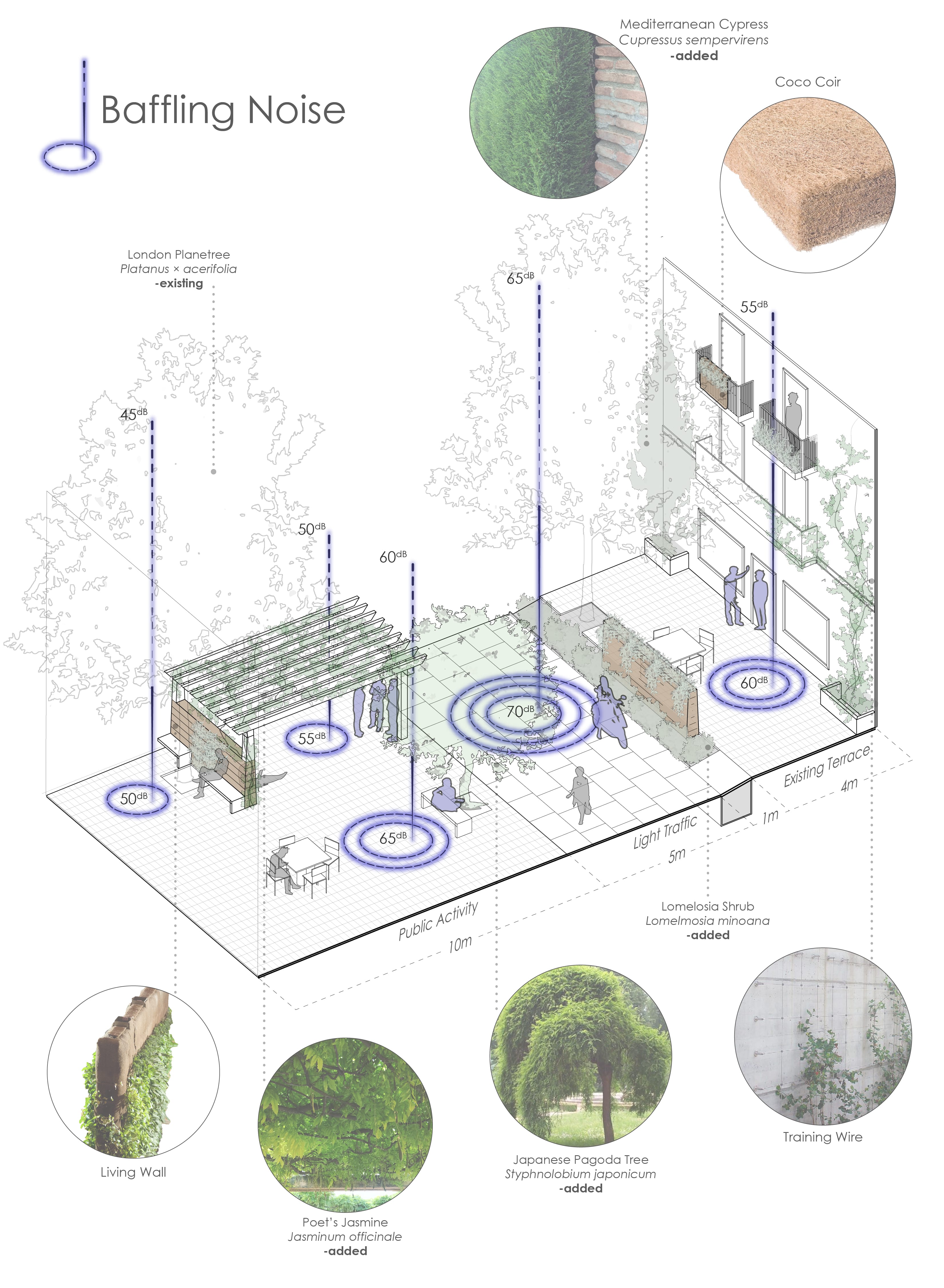
- Vegetation Catalog: 1) trees (canopy); 2) shrubs; and 3) ground cover (incorporated into street-level perspective / axon or aerial view)
Wednesday
Crits
Santa & Cole; Escofet; https://www.urbidermis.com/ https://www.escofet.com/; https://www.bega-us.com/
Week 5 Workshop to develop skills (GH plugin social data) and Design
Monday
[Software Skills]:
- Post-processing (z-line tool)
- Circle tool [polar array]
Group Crits
Wednesday
Group Presentations of Mid term of project due Wednesday. 25%
W6
Monday
Next review; Final review (critics?)
- Crits; 2) Students decide: final deliverables; slideshow or posters; and confirm unit design elements
Reminders: Dropping pins in Google My Maps: Minute 22:00
Illustrator Z-Line Post processing
Wednesday
Crits
W7 Refine designs
Monday: Presentation*. 30% (1 review with Philip + 1 partner group review)
Wednesday
Project Crits
W8
Monday – no class
Final project submission – Wednesday, Sept 9th, 3pm* 35% (Ihab, Kevin Nute, Mary Polites)
* Indicates graded assignment.