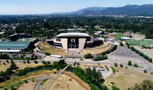
UAV Imagery – Autzen Stadium and Much More!
In preparation for several upcoming workshops on UAVs/Drones that I am offering through the Price Science Commons and Research Library, I needed to update the geofencing on the UO Library’s DJI Phantom IV UAV/Drone and ensure that everything was working well. I spent a few minutes yesterday running through my checklist which included checking on the UAV’s camera. From the scene above, it looks like it was working well. The UAV is available for use on research projects and other university or academic related projects. For example, I will be helping Valerie Sahakian from the UO’s Earth Science Department teach students how to use a UAV to 3D model and calculate the volume of a landscape item. In this case we are looking at the volume of a large obsidian flow next to the Newberry Crater just south of Bend and we will have students flying UAVs to capture the imagery.


