
The interaction of landsliding and tectonics in northern California

At geological timescales tectonics set the boundary conditions for landscape evolution and dynamics. In settings of steady tectonic uplift, it has been suggested that once slopes reach threshold gradients, landslide flux accommodates uplift and limits topographic development. The timescale and process linkages required for landscapes to become threshold slope-dominated, however, involve the consideration of multiple geomorphic lag times and feedbacks. Understanding these lag times and feedbacks is the focus of my current Postdoc research on landslide and landscape response to tectonic uplift connected to the northward migration of the Mendocino Triple Junction (MTJ) in northern California.
I mapped ~3000 landslides from high-resolution aerial imagery in Google Earth and extracted channel steepness index in catchments spanning the path of the MTJ. I also helped to develop a new automated tool to map slope-break knickpoints. Comparison of these datasets with the modeled uplift pattern and topography reveals a strong, coupled response of channels, hillslopes and topography to uplift. Landslides are triggered on slopes flanking steep, rapidly incising channel reaches downstream of migrating knickpoints generated by uplift at channel outlets. Coincident with the onset of landsliding is the reduction of local relief, slope gradients and elevation. Landslides effectively act as a buzz saw, leveling off the topography, whilst the ongoing southward propagation of the landslide buzz saw appears to be limited by the migration rate of knickpoints
Bennett, G.L., Roering, J.J., Miller, S.R., Kirby, E., Schmidt, D. Landslide response to rock uplift along the Mendocino Triple Junction, California. GSA 2014.
Bennett, G.L., Roering, J.J., Miller, S.R., Kirby, E., Schmidt, D., Active landsliding and landscape denudation in response to transient tectonic uplift, northern California. AGU 2014.
We are currently preparing these findings for publication.
Quantifying and modeling sediment transfer through mountain basins
Quantifying sediment yield from mountain basins is of considerable societal significance because it is the main source of sediment transported to lowland and coastal regions and because mountain basins are particularly susceptible to environmental change, in particular to climate change. However, quantification of the response of sediment yield to climate forcing is still a developing field, lacking good field datasets and a solid conceptual framework in which to interpret the data. Together with Peter Molnar, ETH Zurich, and Brian McArdell, WSL, I addressed these research gaps in the Illgraben, a Swiss catchment prone to large slope failures and debris flows, within the research project, SedyMONT (http://www.sedymont.sbg.ac.at/).
1. Erosional power in the Swiss Alps: characterization of slope failure at the head of the Illgraben
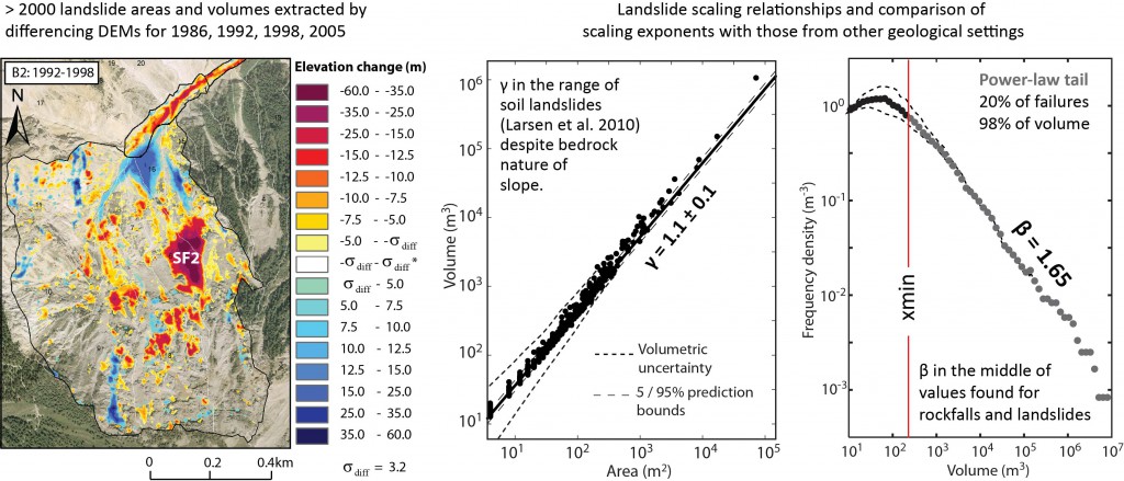 We used digital photogrammetry to produce a multi-temporal record of erosion of a rock-slope at the head of the Illgraben spanning 42 years (1963 – 2005) . We extracted an inventory of ~2500 slope failures for 3 epochs of 6–7 years between 1986 and 2005 ranging over 6 orders of magnitude in volume and eroding the slope at a mean rate of 0.39 m/yr. The failures have a characteristic magnitude frequency distribution with roll-over at 50m³ and a power-law tail > 233m³ (xmin). We suggest that this distribution arises from two different slope failure processes on the basis of the depths and pre-failure slope gradients of slope failures.
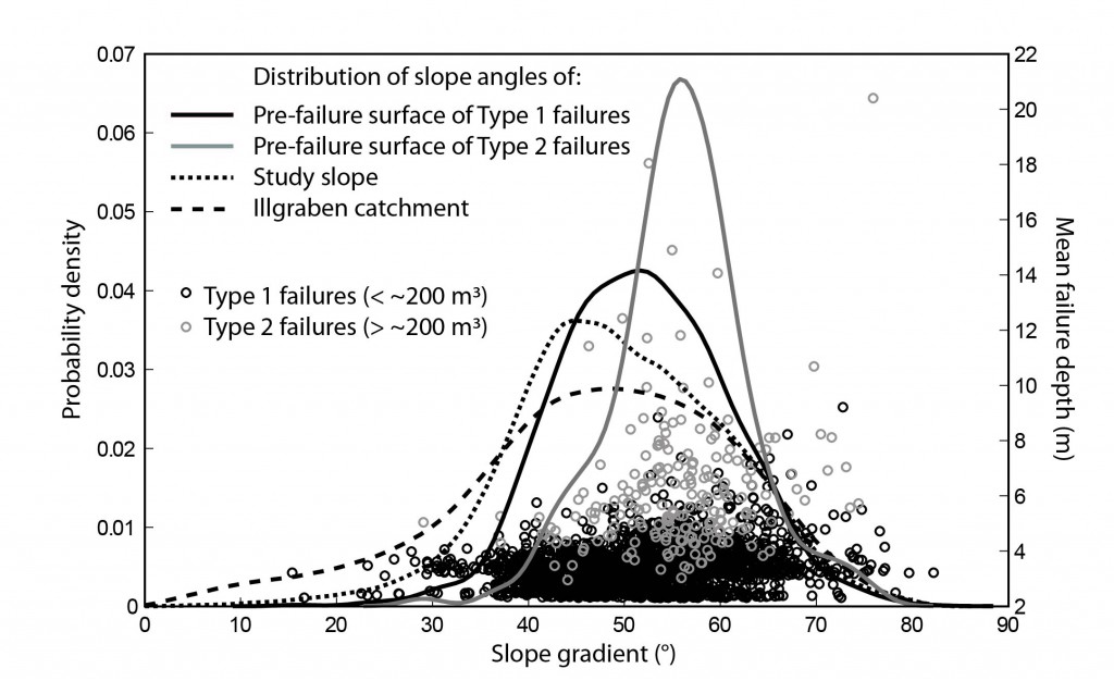
Type 1 failures are frequent small slumps and slides of restricted depth and thus modal size (roll-over) within the upper, weathered layer of the slope.
Type 2 failures are larger and deeper rock slides that occur mainly above a threshold slope of 45˚ probably along discontinuities within the slope. The heterogeneous nature of the internal slope results in a range of failure depths and thus volumes and results in power-law scaling. The power law model of slope failures is ultimately utilized in the sediment cascade model, SedCas.
Bennett, G.L., Molnar, P., Eisenbeiss, H., McArdell, B.W. (2012) Erosional power in the Swiss Alps: Characterizing slope failure at the head of the Illgraben. Earth Surface Processes and Landforms,Vol 37, 1627-1640.
2. Patterns and controls of sediment production, transfer and yield in the Illgraben
We analyzed photogrammetric records of slope and channel erosion and deposition, along with climatic and seismic variables over the period 1963 – 2005 to understand the controls on sediment production and transfer in the Illgraben. We found that the near doubling in hillslope erosion rate in the 1980s is most likely explained by an increase in thermal weathering of the slope related to a significant increase in air temperature and decrease in snow depth and duration. The rate of channel change is related to the frequency of intense summer rainstorms.

In terms of hillslope-channel coupling, in contrast to the widely accepted case of upslope-directed coupling, in which the rate of channel incision controls the rate of hillslope erosion, our study demonstrates a downslope-directed coupling relationship, in which the hillslopes eroded more rapidly and independently of channel incision. This finding illustrates the potential for first order control of hillslope erosion on catchment sediment yield and landscape evolution at decadal timescales.
Bennett, G.L., Molnar, P., Schlunegger, F., McArdell, B.W., Burlando, P. (2013) Patterns and controls of sediment production, transfer and yield in the Illgraben, Switzerland. Geomorphology, 188, 68-82.
3. Modeling sediment transfer through the Illgraben
Mountain basin sediment discharge is inherently nonlinear and stochastic in its relationship to climatic forcing and sediment production. This leads to difficulties in the prediction of sediment discharge and making inferences about environmental change from sediment yield data alone. The nonlinearity in sediment discharge may arise from several sources, of which storage effects, geomorphic thresholds, and connectivity are generally thought to be the most important.
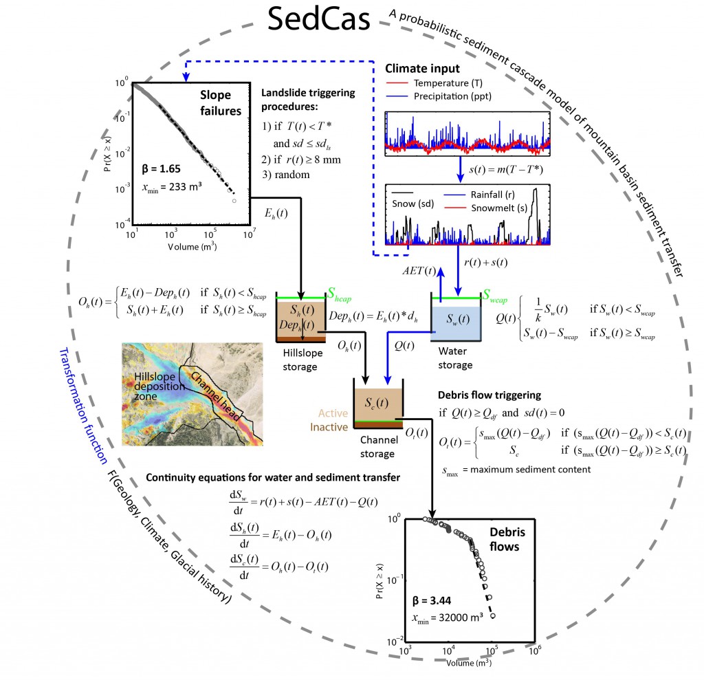
We implement the effects of storage, thresholds, and connectivity in a simple conceptual model of sediment transfer with which the nonlinearity and stochasticity in sediment discharge can be captured. The model is based on the notion of a sediment cascade, which conceptualizes the fluvial system as a cascade of connected reservoirs representing different landscape compartments (e.g., hillslopes and channels) where sediment goes through multiple cycles of storage and remobilization before being discharged from the basin.
Although the processes of sediment transfer and debris flow generation are described in a simplified manner, SedCas produces complex sediment discharge behavior which is driven by the availability of sediment and antecedent wetness conditions (system memory) as well as the triggering potential (climatic forcing). It successfully reproduces the first order properties of sediment discharge including the observed probability distribution of debris flow volumes and their seasonality in 2000–2009.
We use SedCas to show that debris flows may be generated for a wide range of rainfall intensities because of variable antecedent basin wetness and snowmelt contribution to runoff, which helps to understand the limitations of methods based on a single rainfall threshold for debris flow initiation in Alpine basins.
Bennett, G.L., Molnar, P., McArdell, B.W., Burlando, P. (2014) A probabilistic sediment cascade model of sediment transfer in the Illgraben. Water Resources Research, 50, doi: 10.1002/2013WR013806.
We are currently using SedCas to predict future sediment yield in the Illgraben using stochastic downscaled climate realisations of regional and global climate models.
Glacier retreat and landform production on an overdeepened glacier foreland: the debris-charged glacial landsystem at Kvíárjökull, Iceland
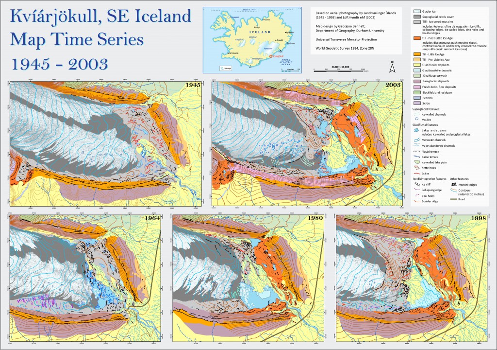
The accuracy of reconstructions of palaeo-ice dynamics and climate hinge on the development and refinement of process-form relationships and landform assemblages at present day ice margins. We quantified glacier recession and landform development of a ‘debris-charged’ glacier characterized by an overdeepening using digital photogrammetry and mapping of the Icelandic glacier, Kvíárjökull.
Between 1945 and 2003 Kvíárjökull retreated by incremental stagnation in which downwasting and retreat was punctuated by minor advances. Debris concentrated at the snout during glacier advance (e.g. 1980 – 1998) protected underlying ice during subsequent ablation dominant conditions resulting in the periodic detachment of the snout to form pushed ice-cored moraine complexes. The distribution/preservation of these complexes in the glacier foreland was and continues to be determined by the configuration of the internal drainage network of the snout, in combination with confinement by the latero-frontal moraine arc and the emergence of the overdeepening into which debris rich ice masses are being reworked.
The recent phase of glacier retreat forms the latter of two phases of retreat and landform production that are likely typical for glaciers retreating over overdeepened forelands: an early phase of active, temperate recession recorded by push moraines and lateral moraines and unconfined pro-glacial meltwater drainage; and a subsequent phase of incremental stagnation with ice-cored moraine and pitted outwash head development initiated by the increasing topographic constraints of the latero-frontal moraine arc and the increasing importance of the overdeepening as a depo-centre.
Bennett, G.L. and Evans, D.J.A. (2012) Glacier retreat and landform production on an overdeepened glacier foreland: the debris-charged glacial landsystem at Kvíárjökull, Iceland. Earth Surface Processes and Landforms, Vol 37, 1584-1602.
Bennett, G.L., Evans, D. J. A., Carbonneau, P. and Twigg, D. R. (2010) Evolution of a debris-charged glacier landsystem, Kvíárjökull, Iceland., Journal of Maps, v2010, 40-67. 10.4113/jom.2010.1114.