Portland, Oregon’s planning department creates engaging documents that invite the public to get involved in shaping the city’s future. Our SE 10th and Division site is located between the Central Eastside Industrial District and a vibrant node for an attractive residential area. Development is spurred by the new Orange Line MAX light rail station and heavy real estate demands.

 The Green Loop: a vision for livability and sustainability. Graphic story of how to create a healthy, sustainable, pedestrian friendly connected core.
 Portland Urban Design Direction, August 2015, sets the current direction within the city’s historic development (21MB booklet + Framework map)
 City of Portland’s SE Quadrant Plan, July 2015 details the neighborhood implementation of the comprehensive plan.
 Portland Maps reveals zoning, lot value, transportation, utilities and ownership, etc.with a Web-based viewer of Geographic Information System data.
CENTRAL EASTSIDE
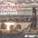 Central Eastside Reader by the City of Portland’s Bureau of Planning and Sustainability
- The Evolution of Portland’s Central Eastside by Angela Guo, PSU Center for Real Estate Quarterly Report, vol. 8, no. 2. Spring 2014 – w images of development in process.
- OMSI-Clinton: A Corridor for Invention and Innovation, 2013 Portland State University Urban Design Workshop lead by Don Stastny and Edward Starkie
- Clinton SE 12th Station area analysis in the Portland Milwaukie Orange Line conceptual design report
PORTLAND ARCHITECTURE
- Next Portland: Architecture and Urban Development in PDX blog on architecture and urban development. See what is being proposed and in construction by whom and where.
- Portland Architecture blog about design in the Rose City by Brian Libby.