My father Todd Fonstad began the Images of Wisconsin project in the 1990’s, and I helped out here and there along the way. The original slide collection of aerial imagery taken by hand by pilot Carl Guell has been carefully scanned, and the individual images have been geolocated, described and interpreted. The entire collection is a snapshot of the state of Wisconsin from the 1950s through the 1980s. The digital collection contains about 1300 described slides at high resolution. I plan to develop this site to allow users to access all of the slides at their full resolution. Until then, I am posting a few dozen lowered-resolution examples along with their descriptions. The physical slides are now held by the Wisconsin State Historical Society, and all rights are reserved by the WSHS. If you are interested in the digital version of a particular slide, let me know and I see what I can do for you.
A simple database of the entire collection can be downloaded here: Guell_Super_Matrix

ZOO CONSTRUCTION
Milwaukee, Milwaukee County. October, 1960. Altitude c. 2,500 ft. Milwaukee County Zoo, under construction, is at the center of view to the north-northwest.
ZINC MINE
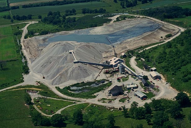
Shullsburg, LaFayette County. May, 1970. Altitude c. 1,000 ft. The Eagle Picher Company zinc mine is at center of this low altitude photograph. A large tailings pile, settling pond, and buildings comprise the operation. This mine is now closed. Zinc production in southwestern Wisconsin began in 1860, peaked in 1918, and ended in the early 1970s.
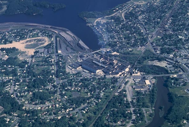
RAILROAD YARDS
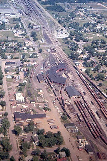
Stevens Point, Portage County. July 6, 1975. Altitude c. 1,500 feet. The Soo Line (now Wisconsin Central) yards, on Stevens Point’s south side, extend for some distance east-to-west in this view. Many parallel tracks, a roundhouse, and several trains are in sight.
A DRIFTLESS LANDSCAPE
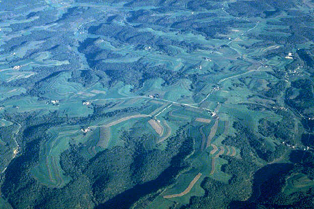
Coon Valley, Vernon County. September, 1968. Altitude c. 5,000 ft. The ridges and valleys of the unglaciated (driftless) Western Upland are seen in this expansive, high-altitude oblique view. Small streams, such as that at lower left, have cut a dendritic pattern of deep, narrow valleys. A low sun angle emphasizes steep intervening slopes, most of which are covered with broadleaf forests. Contour plowing and strip cropping are prominent on the broader ridgetops. The numerous farmsteads there have experienced a significant decline in numbers in the three decades since the photograph was taken.
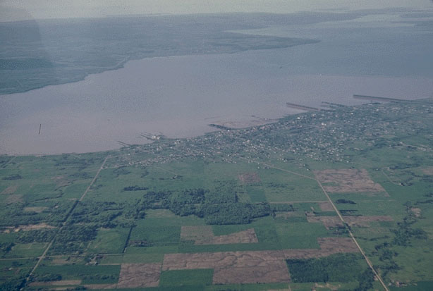
WISCONSIN AND MISSISSIPPI RIVERS
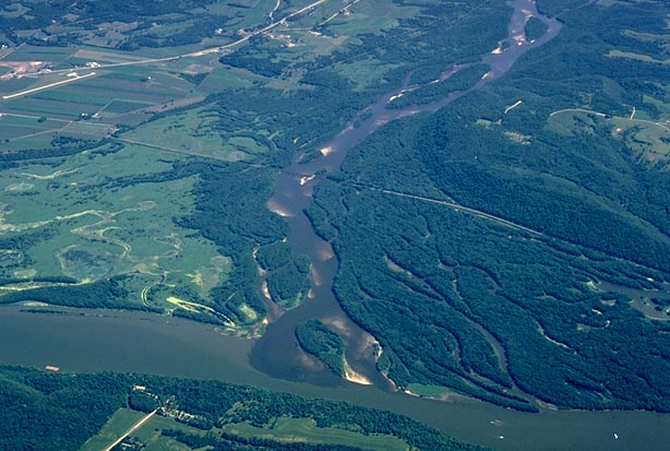
Prairie du Chien, Crawford County. August, 1970. Altitude c. 4,000 feet. The dark, almost purple waters of the Wisconsin River meet the lighter-colored Mississippi River south of Prairie du Chien. Several distributaries fan out from the Wisconsin’s mouth. The delta is almost entirely covered by forest, but toward the north (left), marshland is present. Wyalusing State Park is at upper right. The Burlington Northern RR track bisects the area from upper left to lower right. A runway at the Prairie du Chien Airport is at upper left. The state of Iowa is at bottom. The camera looks up the Wisconsin River Valley to the ENE.
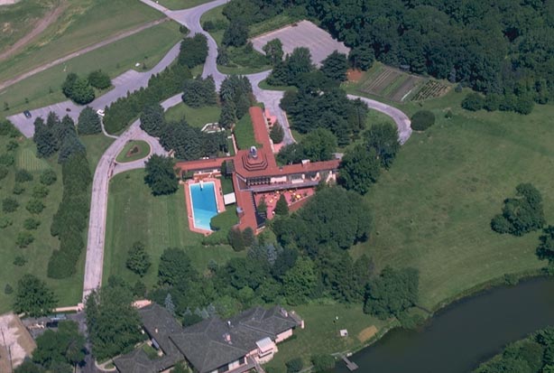
WINGSPREAD
Racine, Racine County. July, 1968. Altitude c. 1,000 feet. Wingspread was designed as a home for Herbert F. Johnson, head of the Johnson Wax Company by the Wisconsin-born architect Frank Lloyd Wright. Now headquarters of the S.C. Johnson Foundation, its red roofs and blue swimming pool contrast with the surrounding greens of lawn, shrubs, and trees. Built in 1937, Wingspread was the last of Wright’s Prairie designs.
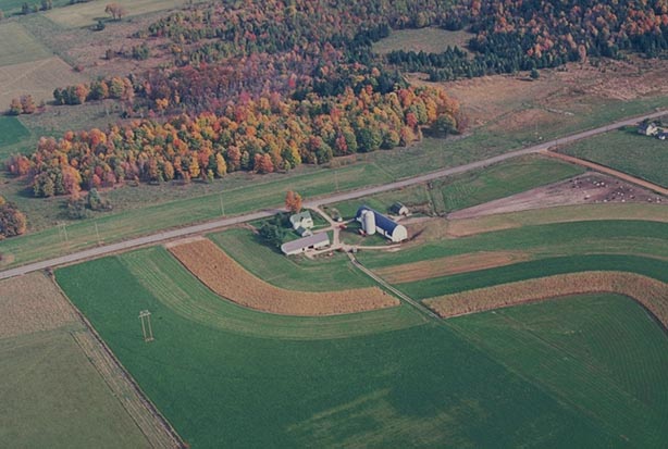
FARM SCENE
Wausau, Marathon County. Oct.,1969. Altitude c. 2,500 ft. A farmstead and adjoining cropland contrast with colorful autumn foliage of the nearby woodlot east of the city.

ROCK PILES
Wausau, Marathon County. Late 1950’s. Altitude c. 1,500 ft. A dozen or more circular and linear piles of rock are scattered throughout a farmer’s field about ten miles north of Wausau. Clearing the land of rocks as well as trees was a first order of business for many agricultural settlers in the past. Most of these rocks are granitic.
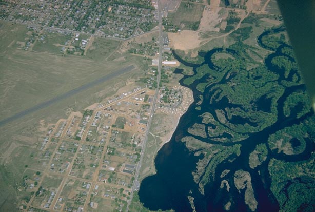
DELTA OF THE EAU CLAIRE RIVER
Wausau, Marathon County. May 23, 1958. c. 4,000 ft. A semi-circular trailer court is seen at center, near the end of the SW-NE runway of the Wausau Municipal Airport, in this low oblique view to the north. Business Highway 51 runs between the airport and trailer court. To the right (east) are the distributaries of a delta built by the Eau Claire River which joins the Wisconsin River here.
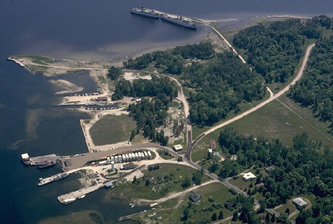
WASHINGTON ISLAND’S DETROIT HARBOR
Washington Island, Door County. August, 1966. Altitude c. 1,500 feet. The harbor facilities at Washington Island’s Detroit Harbor are seen in low oblique to the south. Two former car ferries are moored at dockside (top). These car ferries are being used to store potatoes, grown on the island, to be shipped to Chicago. Several cars await the arrival of another ferry along a dock at lower left. White fuel storage tanks are at bottom center. The island lies off the tip of Wisconsin’s Door Peninsula.
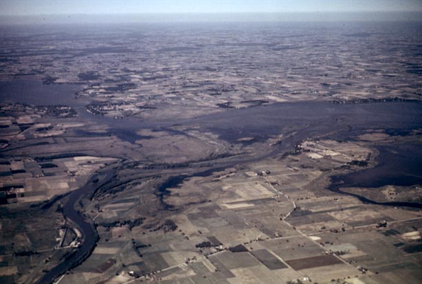
UPPER FOX
Near Omro, Winnebago County. Summer. Date Unknown (c. 1950s). Altitude c. 5,000 ft. The Upper Fox River, lower left, empties into the southwest corner of Lake Butte des Morts, center, in this high altitude view to the NNE. Most of the surrounding area is farmland in this clay-rich former glacial lakeplain. The Village of Winneconne and a portion of Lake Winneconne appear toward upper left.
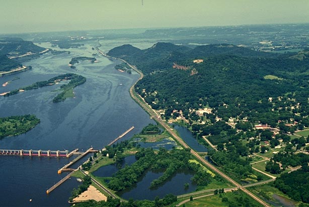
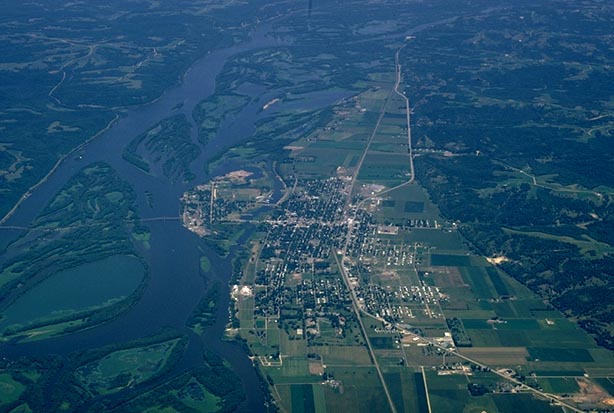
TREMPEALEAU
Trempealeau, Trempealeau County. July, 1969. Altitude c. 3,000 ft. This high oblique view to the northern horizon features a lock and dam (No. 6) on the Mississippi River, Trempealeau Mountain (an isolated bluff) at center, and the village of Trempealeau at lower right. Trempealeau Mountain is within Perrot State Park. Bluffs along the west side of the river valley in Minnesota are visible at upper left.
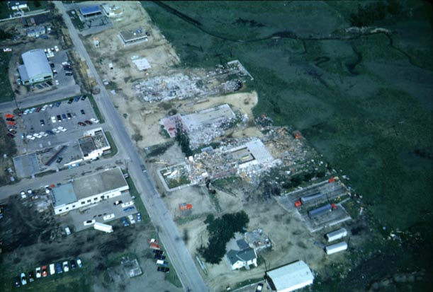
TORNADO DAMAGE
Monroe, Green County. July, 1965. Altitude c. 2,000 feet. Several wholly or partially-destroyed buildings can be seen along the far side of a street on the edge of the city. The funnel appears to have moved from lower left to upper right.

TALIESIN
Near Spring Green, Iowa County. May, 1970. Altitude c. 2,000 ft. Taliesin and other Frank Lloyd Wright buildings are seen in this oblique photograph looking to the northwest from a point over Highway 23. Taliesin, Wright’s home, is sited on a bluff at upper right. Midway Farm is at lower left.
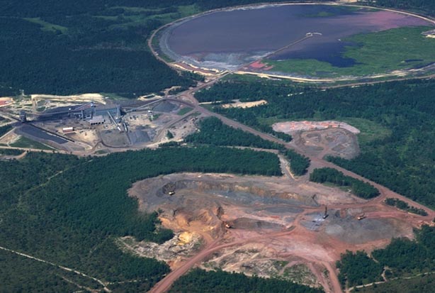
TACONITE PELLETIZING OPERATION
Black River Falls, Jackson County. October 27, 1975. Altitude 4,000 ft. All portions of the Jackson County iron mining operation, a subsidiary of the Inland Steel Corporation, are in this oblique view to the northeast. The open pit mine is in the foreground, the pelletizing plant is at left center, and the settling pond for waste disposal is at upper right.

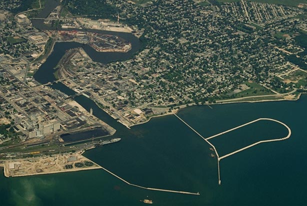
SUPERIOR ORE DOCKS
Superior, Douglas County. June 3, 1975. Altitude c. 3,000 ft. Several iron ore docks project into the waters of Superior Bay. One ore ship is at a dock. The spit of land at top left is Wisconsin Point. At lower right is the mouth of the Nemadji River. View is to the east.

AIMLESS STREAM
Dundee, Fond du Lac County. June, 1965. Altitude c. 3,500 ft. A small stream meanders aimlessly across the Kettle Moraine landscape in this low oblique photograph. Adjacent uncultivated and unwooded areas are wetlands. Aimless streams and wetlands are hallmarks of the deranged drainage patterns of newly-glaciated landscapes such as this.
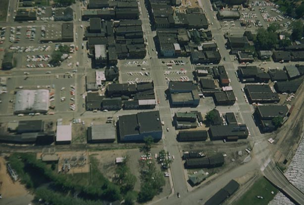
THE SQUARE
Stevens Point, Portage County. May, 1964. Altitude c. 1,500 ft. The famous city “Square” is in the center of this low oblique view to the east. Main Street crosses the square, from top to bottom view. Parking spaces there are clearly marked. In late summer many will be occupied by fruit, vegetable, and flower vendors. The square is also known for its taverns. A portion of the Wisconsin River is at lower right.
SKI JUMP
Westby, Vernon County. September, 1970. Altitude c. 1,500 ft. A ski jump is perched on a small divide high above an adjacent stream valley about three miles north of Westby in this view to the south. The ski jump is ninety feet tall. The judges’ observation tower is at center, about one-third the distance down the ski hill. The stream valley, at bottom left, is the site of a golf course. Norwegian immigrants, who began settling this area in the mid-1800s, are responsible for the introduction of the sport.
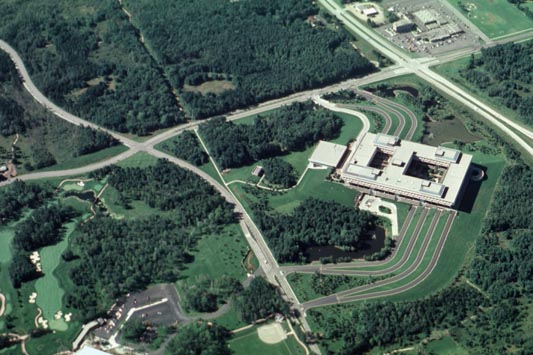
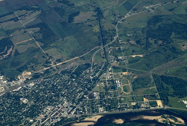
SENTRY INSURANCE
Stevens Point, Portage County. August, 1984. Altitude c. 2,000 feet. The headquarters of the Sentry Insurance Company as well as a portion of its highly-regarded golf course (lower left) on the north side of the city is seen in low oblique.
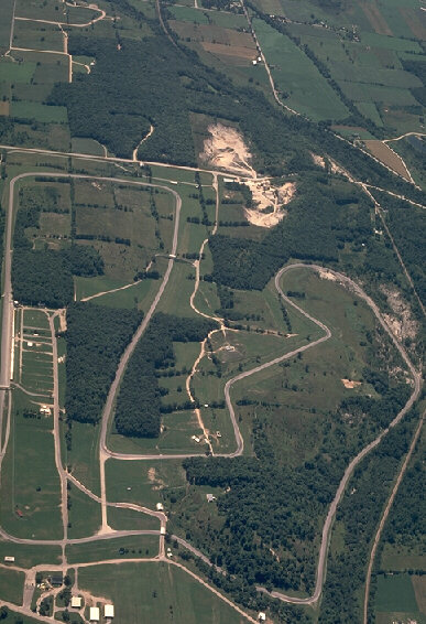
ROAD AMERICA
Elkhart Lake, Sheboygan County. August, 1975. Altitude c. 4,000 feet. The entire Road America course is seen in this low oblique perspective to the NNE. Located in the rolling Kettle Moraine landscape of eastern Wisconsin about two miles southeast of Elkhart Lake, it is considered by many drivers to be among the very best of road tracks in the country.

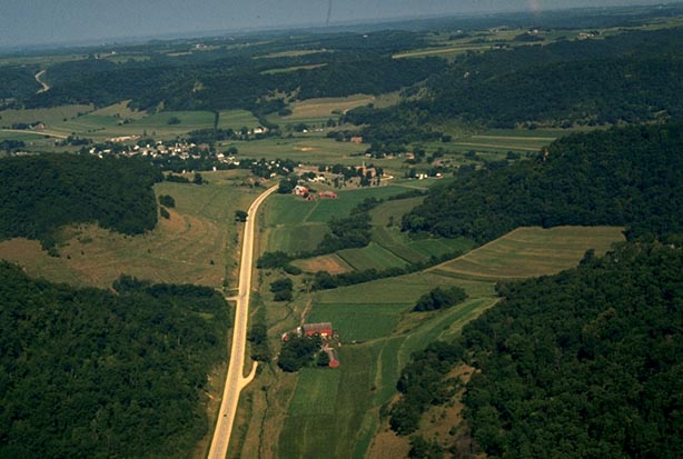
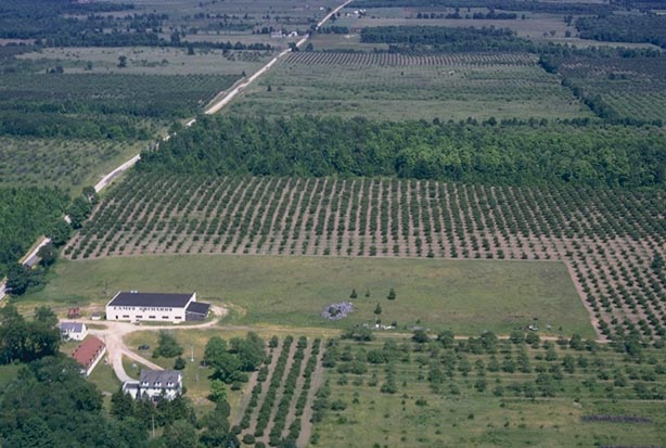
RIDGETOP CROPS
Gays Mills, Crawford County. July, 1969. Altitude c. 1,500 ft. A series of apple orchards flank a road which curves along a ridge crest in the state’s unglaciated region. Woodlots and fields extend up toward the orchards from adjacent valley bottoms and sides. Frost damage to apple blossoms in spring and the apples in autumn is minimized by the siting of orchards on ridge tops. Cold air sinks to the valley bottoms in the process called “air drainage”, leaving temperatures on the crests significantly warmer.
RHINELANDER
Rhinelander, Oneida County. August 28, 1968. Altitude c. 3,000 ft. The Rhinelander Paper Company, on the west bank of the Wisconsin River, is viewed in low oblique from south to north. Rhinelander’s central business district is at far right. A straight stretch of CNW RR tracks extends through the city from lower left to upper right. Wisconsin is the nation’s premier paper-making state.

CAMP RANDALL
Madison, Dane County. August, 1966. Altitude c. 1,500 ft. The University of Wisconsin-Madison’s Camp Randall Stadium and Fieldhouse (red roof) are seen from a low oblique perspective to the west. The natural turf of the football field, seen here, has since been twice replaced by an artificial surface. Most athletic activities which took place in the Fieldhouse have been moved into the newly built Kohl Center nearby.
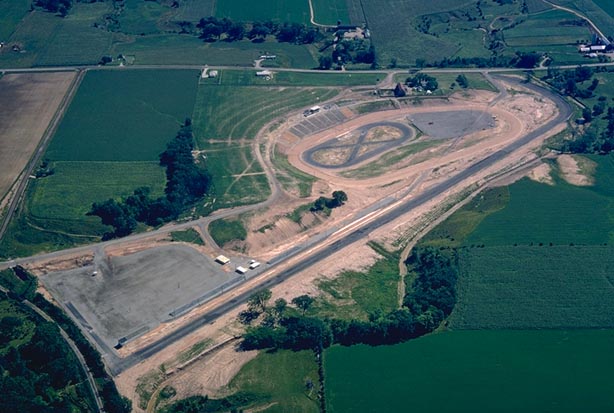
RACEWAY CONSTRUCTION
Kaukauna, Outagamie County. August, 1966. Altitude c. 2,000 ft. The straight asphalt surface of the newly-built ‘KK’ drag strip runs from lower left to upper right. It is a quarter mile (plus) in length. Above it, toward upper right, is the figure-eight oval used for other types of automobile races. Spectator stands are in the process of being built. The facility is now the ‘Wisconsin International Raceway’, located about two miles south of Kaukauna.
HISTORIC PORTAGE
Portage, Columbia County. September, 1967. Altitude 10,000 feet. The city of Portage is seen in an oblique view to the northeast. The channel of the Wisconsin River, containing several sand islands, is at lower right. The Upper Fox River, here only a small stream, meanders across the upper portion of the view. The prominent Fox-Wisconsin Canal connects the two rivers. It is approximately 1 1/2 miles in length. No longer in use, it was built in the mid-nineteenth century to connect the two rivers which historically comprised the only east-west transportation route across Wisconsin, from Green Bay on the Great Lakes to Prairie du Chien on the Mississippi.
PUBLIC LAND SURVEY
Green Bay, Brown and Kewaunee Counties. June, 1969. Altitude c. 8,000 feet. Section line roads and rectangular fields form a checkerboard pattern on the gently rolling landscape northeast of Green Bay on the lower Door Peninsula. The Public Land Survey (PLS), responsible for this pattern, was instituted by the federal government when it passed the Ordinance of 1785.

PLATTE MOUND
Near Platteville in LaFayette County. May, 1970. Altitude c. 3,500 ft. Platte Mound is at center in a high oblique view to the northeast. This flat-topped outlier of Niagaran Dolomite rises 300 feet above the surrounding landscape. A large white letter “M” embellishes the near side of the mound. It represents the early emphasis on mining technology (lead and zinc)at the nearby University of Wisconsin-Platteville.
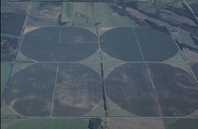
CENTER PIVOT IRRIGATION
Bancroft, Portage County. June, 1977. Altitude c. 6,000 feet. Four center pivot irrigation systems have created circular field patterns in an area of the “Golden Sands” agricultural region in central Wisconsin. The four circular fields occupy an entire section of land (640 acres). The Golden Sands is an outwash plain at the margin of a Late Wisconsin terminal moraine.
PRAIRIE DU CHIEN
Prairie du Chien, Crawford County. August, 1970. Altitude c. 8,000 feet. The entire city of Prairie du Chien is in view in this high oblique, northward-oriented photograph. Many wooded islands appear in the channel of the Mississippi River, and Iowa can be seen at upper left. Prairie du Chien (center and lower right) is situated on the floodplain and low terraces of the Mississippi River. Wooded bluffs mark the eastern limit of the river valley at right. Remnants of the French long-lot system are still apparent, particularily to the north of the city. Prairie du Chien and Green Bay are the oldest communities in the state, having been settled by the French during the 1600’s.

OSHKOSH
Oshkosh, Winnebago County. Date unknown (early 1950s). Altitude c.6,000 feet. This almost horizontal view to the northwestern horizon reveals much of the city of Oshkosh and the bodies of water which figured into its historical development. Most distant is Lake Poygan (with its associated Lake Winneconne). Lake Butte des Morts is at center. Waters from the Upper Fox and Wolf Rivers discharge into those two upper lakes. From Lake Butte des Morts, the Fox River bisects the city, emptying into Lake Winnebago (bottom), the largest body of water in Wisconsin. By 1900, Oshkosh led the world in the production of wood products, and forty-four sawmills lined the banks of the Fox River, using timber floated down the Wolf River from northern Wisconsin’s ‘Pineries’. Today, Oshkosh is a city of over 50,000 with a diversified industrial base. South of the river, residential and commercial areas have grown well beyond Highway 41, the north-south highway which spans the Fox River at right center. The white area at far left is the Vulcan Quarry (dolomitic limestone), now over a century old and considerably larger than shown in this image.
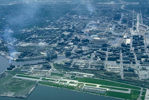
OLD MILWAUKEE
Milwaukee, Milwaukee County. July, 1965. Altitude c. 4,000 feet. Taken from a location over Lake Michigan looking toward the west along the industrial Menominee River Valley, this photograph reveals the Menomonee and Kinnickinnic Rivers at left, 1-794 at left center, and the Milwaukee River at right center. Milwaukee’s Municipal Pier juts into the lake at lower center. The War Memorial Building and Art Center are toward lower right, between Lincoln Memorial Drive and Lake Michigan. An airfield, along the shoreline at bottom, is now the site of the Milwaukee Summerfest grounds.
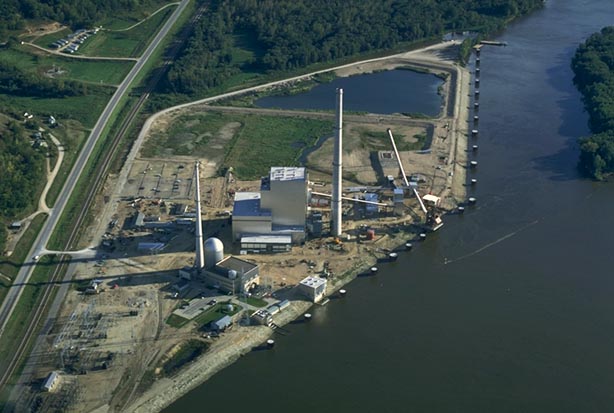
FIRST NUCLEAR PLANT
Genoa, Vernon County. 1974. Altitude c. 1,000 ft. The entire Dairyland electrical-generating operation is seen in an oblique view to the SSE from a position over the Mississippi River. The plant generates steam both by burning coal and by nuclear fission. The silo-like structure at lower left houses the nuclear reactor. It is the state’s oldest and smallest of the state’s three nuclear plants.

NEW GLARUS
New Glarus, Green County. July, 1969. Altitude c. 1,500 ft. Virtually the entire community of New Glarus, famous for its residents of Swiss ancestry, is seen below in this view to the southeast. The city is situated in the valley of the Little Sugar River on Highway 69, seen bisecting the photo from left to right. The central business district, with a number of “Swiss historic sites”, is at lower left.

NEOPIT
Neopit, Menominee County. June 7, 1970. Altitude c. 6,000 ft. The small community of Neopit is surrounded by green forests in this view to the east. A mill pond, west of Neopit (lower), is formed by the damming of the Little West Branch of the Wolf River. A sawmill operation and piles of logs comprise a large cleared area on the community’s west side adjacent to the river. The Menominee Nation’s forest cover was spared from the clear-cutting which destroyed the state’s northern forests during the 1860- 1920 period. Logging today takes place here on a managed basis, and the Menominee forest is therefore virtually the only major representative of what was the original northern mixed forest.
TWIN CITIES
Neenah and Menasha, Winnebago County. August, 1980. Altitude 9,500 feet. The “twin cities” of Neenah (lower) and Menasha (upper) are seen in an oblique view to the NNE. Doty island is at center, surrounded by the divided channels of the Lower Fox River as it discharges from nearby Lake Winnebago (out of view to the right) on its way toward Green Bay. Paper mills comprise much of the industrial base of this area, which boasts the heaviest concentration of paper producers in the world.

BAILEYS HARBOR
Baileys Harbor, Door County. August, 1966. Altitude c. 4,000 feet. Baileys Harbor, along the Door Peninsula’s Lake Michigan shoreline, is seen to the east. Submerged bars, white sand beaches, and numerous inland sand ridges are prominent. Ridge Road (Rustic Road 39) follows the curve of the bay. A nature preserve, The Ridges Sanctuary, is to the north (left) of the road.

MISSISSIPPI RIVER VALLEY
Cassville, Grant County. August, 1970. Altitude c. 3,000 feet. This is an expansive, high oblique view of the Mississippi River valley to the northwestern horizon. The community of Cassville is at center, its two coal-fired electrical generating plants prominently spewing white plumes of smoke westward over the river. In the foreground, on a low terrace near the river, is the runway of the Cassville Municipal Airport. Adjacent to the runway near the base of the wooded bluff are the tracks of the Burlington Northern Railway and County Highway VV. Iowa lies across the valley at upper left, and the city of Guttenberg is just visible within the valley at upper right.

A CULTURAL FAULT LINE
Phlox, Langlade and Menominee Counties. August, 1968. Altitude c. 8,000 feet. The straight-as-an-arrow western boundary of Menominee County (Menominee Indian Reservation) extends away from the observer in this view to the northern horizon. The green forest cover of the reservation at right contrasts vividly with agricultural lands in Langlade County to its west (left). White pine and other species were never clearcut on the reservation during the great logging boom of the late nineteenth and early twentieth centuries. Areas of wetland jut out from the border into farm lands in several places. The light-colored surface of the eastern portion of the “Antigo Flats” outwash plain is at far upper left. It is a major producer of potatoes. The dark, wooded margins surrounding it to the southeast and north are terminal moraines of the Wisconsin glaciation.
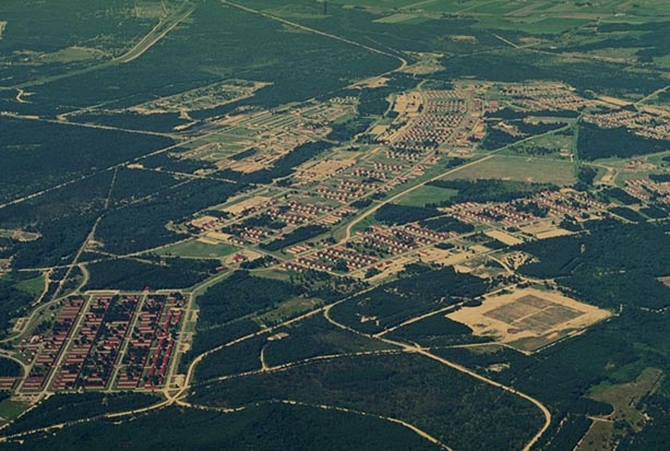
CAMP MCCOY
Camp McCoy, Monroe County. June, 1969. Altitude c. 6,000 ft. Clusters of red-roofed barracks and other buildings of the Army’s Camp McCoy are surrounded by green jack pine forest in this high altitude view to the west.
MANITOWOC
Manitowoc, Manitowoc County. August 17, 1976. Altitude c. 7,000 ft. The northeastern part of Manitowoc is seen to the northwest from over Lake Michigan. In view at center is the city’s harbor and adjacent port facilities. A car ferry is at dockside within the breakwater, presumably ready to discharge its load of motor vehicles, railroad cars, and passengers which originated in Michigan (probably Ludington). A prominent meander of the Manitowoc River, its banks lined with heavy industry, is at upper left. A portion of the city’s central business district is seen at lower left. One of Manitowoc’s ‘claims to fame’ is the recovery of part of a Russian Sputnik which fell from space onto one of its streets in the late 1950s.
LOWER WISCONSIN RIVER VALLEY
Spring Green, Sauk and Iowa Counties. May, 1970. Altitude c. 5,000 feet. Wooded sand islands and submerged sand bars occupy the purplish-appearing waters of the Wisconsin River channel near Spring Green. The sculpted and streamlined shapes indicate the current is flowing from right (east) to left (west). Much of the sand was transported into this portion of the Driftless Area by the enlarged Wisconsin River during glacial times.
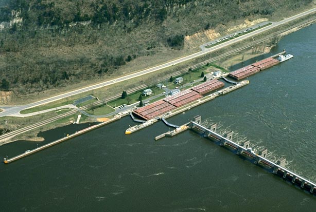
LOCK AND DAM
Genoa, Vernon County. April 24, 1974. Altitude c. 1,500 ft. Lock and Dam No. 8 is at the center of an oblique view toward the southeast from over the Mississippi River. It is located immediately south of Genoa and just north of the power generating facility. The lock hugs the Wisconsin side of the channel. A long train of barges carrying red containers is travelling upstream through the lock. Only eight barges can be accomodated within the lock, while the tugboat and four remaining barges await their turn to gain access.
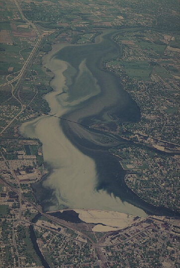
POLLUTION IN LITTLE LAKE BUTTE DES MORTS
Neenah and Menasha, Winnebago County. May 18, 1970. Altitude c. 7,000 feet. Little Lake Butte des Morts is seen in its entirety, stretching from Neenah in the south (bottom) toward Appleton in the north (top). Doty Island, formed by the two channels of the Lower Fox River as they enter the lake from Lake Winnebago (out of view to the east), is at right center. Multi-colored plumes of pollution stream into Little Lake Butte des Morts from “Twin Cities” industries, primarily paper mills. The Clean Water Act of the mid-1970’s has resulted in a significant reduction in mill effluent, but pollutants remain in bottom sediments.
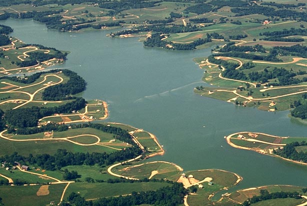
LAKE REDSTONE
Lake Redstone, Sauk County. August 27, 1968. Altitude c. 3,000 ft. Newly-constructed white roads follow every indentation of the shoreline at the north end of Lake Redstone, an artificial lake. Vacation homes and as yet unoccupied building sites, several of which are located around cul de sacs, can be seen. Natural lakes are virtually absent in this unglaciated part of the state.

LAMBEAU FIELD — THE BEGINNING
Green Bay, Brown County. September, 1957. Altitude c. 2,500 feet. Lambeau Field, the Green Bay Packer’s football stadium, is nearing completion in this low oblique view. Residential build-up is only beginning to take place in the surrounding area. The nearby Brown County Arena has not yet been built.

LAKE WINNEBAGO
Lake Winnebago; Calumet, Fond du Lac, Outagamie, Winnebago Counties. Winter, 1970. Altitude c. 11,000 feet. Virtually all of the ice and snow covered surface of Wisconsin’s largest inland body of water is seen to the northern horizon from a point south of the city of Fond du Lac. Almost thirty miles in length and over eleven miles in width, it attains a maximum depth of only about twenty-two feet. The lake is a remnant of the once-larger Glacial Lake Oshkosh.

NORTHERN LAKES
Tomahawk, Lincoln County. September 30, 1975. Altitude c. 5,000 feet. Many small kettle lakes, typical of Wisconsin’s Northern Highland region, are apparent in this view to the northeast. Perhaps ninety percent of this landscape northeast of Tomahawk is forested and in full fall color. Dark green conifers contrast with brightly-colored maples and other hardwoods.
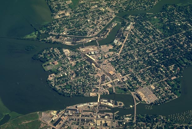
LA CROSSE
La Crosse, La Crosse County. July, 1969. Altitude c. 2,500 ft. This panoramic, high oblique view looks northeast across the Mississippi River toward the La Crosse downtown district. Residential neighborhoods lie beyond, toward upper right. A park and marina are along the west river bank (lower) and a highway bridge (Highway 14,16,61) spans the Mississippi at center. Several boats are in mid channel.
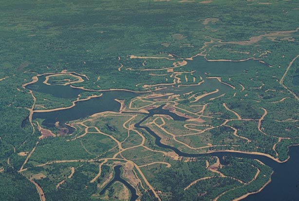
LEGEND LAKE
Keshena, Menominee County. June, 1970. Altitude c. 5,000 ft. A major portion of the Legend Lake Development east of Keshena is viewed in high oblique to the east. Construction of the Lakes of the Menominees by a private developer involved damming a small stream and raising the water level of adjacent lakes to form an interconnected waterway. Termination (“defederalization”) of the Menominee Tribe in 1961 set the stage for this project and the subsequent sale of lake properties to non- Menominees. Subsequent political upheaval within the tribe which, coupled with the economic failure of the termination policy, resulted in the restoration of the nation to federal status in 1973. The lake development, seen here prior to most land sales and home construction, was confined to less than 4% of the county (reservation).
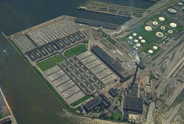
JONES ISLAND
Milwaukee, Milwaukee County. June, 1965. Altitude c. 2,000 ft. The Milwaukee Sewage Treatment Plant is seen in detail in this low oblique view toward the southeast. It occupies the north end of Jones Island, a strip of land to the south of the harbor entrance (seen at left). A fertilizer, Milorganite, is manufactured here.
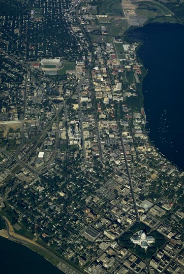
MADISON
Madison, Dane County. September, 1967. Altitude c. 8,500 feet. This low oblique photograph encompasses Madison’s central business district and Capitol Square (lower right) westward beyond Camp Randall Stadium (upper left). Lake Monona is at lower left; Lake Mendota as far as Picnic Point is seen at right. A number of sailboats are anchored just offshore of the Memorial Union Marina on Lake Mendota. Most of the University of Wisconsin-Madison campus can be seen in this view.

ICE FISHING
Lake Winnebago, Winnebago County. Winter, date unknown. Altitude c. 150 ft. Three fishing shanties, several vehicles, and several fishermen are seen on the sunny, frozen surface of northern Lake Winnebago, Wisconsin’s largest inland lake. Gray patches of wind-swept,snow-free ice interrupt its otherwise white veneer. Perch, walleyed pike, and sturgeon (taken only during a special spearing season) are the most sought-after species in winter.
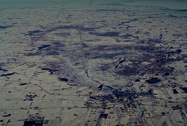
HORICON MARSH
Horicon Marsh, Dodge County. February, 1970. Altitude 11,000 ft. This high altitude, high oblique photograph looks over the entire Horicon Marsh toward the northern horizon. Once a shallow glacial lake, the northern portion of the marsh is now controlled by the federal government, while the southern half is state-regulated. It is a major breeding and “stopover” area for migrating waterfowl. The community of Horicon, its dark-colored streets contrasting against the white snow cover, is at lower right. The city of Waupun is seen as a dark spot toward upper left. Lake Winnebago and the cities of Oshkosh and Fond du Lac are visible at upper right. The Eldorado Marsh is between the north end of the Horicon Marsh and Oshkosh. The Niagara Escarpment at Oakfield is seen as a dark line to the northeast of the Horicon Marsh.
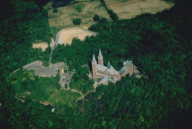
HOLY HILL
Hartford, Washington County. June, 1959. Altitude c. 1,500 feet. The twin spires of the Roman Catholic church and monastery at Holy Hill reach for the sky in Wisconsin’s forested southern Kettle Moraine. The prominent landmark was built upon a moulin kame (a conical hill comprised of sand and gravel, deposited during the waning stages of the Wisconsin glaciation), now the highest point in southeastern Wisconsin.
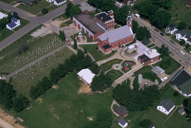
DICKEYVILLE GROTTO
Dickeyville, Grant County. August, 1970. Altitude c. 1,000 ft. A Catholic church in the community of Dickeyville is seen in low oblique. A parsonage, parochial school, cemetery, and grotto (shrine) are located on the church grounds.

GREEN LAKE
Green Lake, Green Lake County. June, 1966. Altitude c. 1,500 ft. The American Baptist Assembly complex on the north shore of Green Lake is viewed in a high oblique view toward the southwest. The arcuate-shaped bay in the foreground is Pigeon Cove, and the bay beyond the assembly grounds is Norwegian Bay. Sugarloaf Point juts prominently into the lake from its northern shore at top center and left. Green Lake is Wisconsin’s deepest natural inland body of water with a depth of about 225 feet.

GREEN (?) BAY
Green Bay, Brown County. June 28, 1969. Altitude c. 8,000 ft. This high oblique view reveals enormous pink streams of natural and industrial pollution, pouring out into the bay from the Lower Fox River. Seen to the southwest from a spot over Highway 57 (northeast of the city) is Green Bay (lower right), the city of Green Bay (center) and the Lower Fox River (upper left to center). ‘Natural’ pollution consists largely of reddish clays which enter the Fox and its tributaries as the result of poor land management practices. Paper mills probably contributed the major share of industrial pollutants. The Fox River has experienced a dramatic improvement in water quality since this photograph was taken.
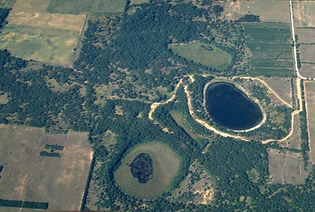
GOING, GOING, GONE
Lawrence, Marquette County. September, 1967. Altitude c. 4,000 feet. Three kettles, formerly all containing lakes, are seen in close proximity to each other and show a sequence of aging. The center kettle, at far right, still contains a small lake which is relatively free of aquatic vegetation. The other two, at upper right and lower center, have only small remnants of visible water, surrounded by wetland vegetation. Such plants may include grasses, sedges, cattails, and other non-woody species. Typically, organic matter formed by the partial decay and preservation of these plants form the substratum. Eventually, most of Wisconsin’s 10,000 to 15,000 lakes will age and ultimately disappear through similar processes of sedimentation and vegetative succession.

FRENCH SURVEY
Green Bay, Brown County. September, 1957. Altitude c. 3,000 ft. Long rectangular property lines, a result of the so-called “French Long Lot” system, are evident perpendicular to the Lower Fox River (lower, extending from lower left to upper right) southwest of Green Bay. Section lines imposed by the later U.S. Public Land Survey system are visible in the middle distance (roads extending directly away from the observer). The runways of Austin Straubel Airport are seen at far right. This is a high oblique view to the west. Haze obscures distant features. The French were the first Europeans to inhabit parts of Wisconsin, beginning in the 1600s. The cities of Green Bay and Prairie du Chien are the oldest communities in the state and some of the original survey units, such as seen in this image, persist today.

FIRST CAPITOL
Belmont, LaFayette County. May, 1970. c. 500 ft. The twin buildings of the Wisconsin Territorial Capitol (1836), located about two miles north of Belmont, are viewed in low oblique. The small, white, red-roofed building at right center is an old-fashioned outdoor toilet. This southwestern portion of what is now the state of Wisconsin controlled territorial politics during the 1820-1840 period when discoveries of lead deposits resulted in a population boom. Wisconsin became the nation’s 30th state in 1848.

PASTORAL LANDSCAPE
Chippewa Falls, Chippewa County. September 30, 1975. Altitude c. 2,500 ft. A rolling agricultural landscape northwest of Chippewa Falls displays an alternation of pasture, strip-cropped cultivated land, and brightly colored deciduous woodlots.

ESKER
Dundee, Fond du Lac County. September, 1957. Altitude c. 1,000 ft. A small esker, perhaps only about 1,500 feet long, is seen as an S-shaped ridge at the center of this low oblique photograph. This landform was deposited as sand and gravel on the bed of a subglacial stream during a period of ice stagnation. Another esker is seen just across the highway at upper center.
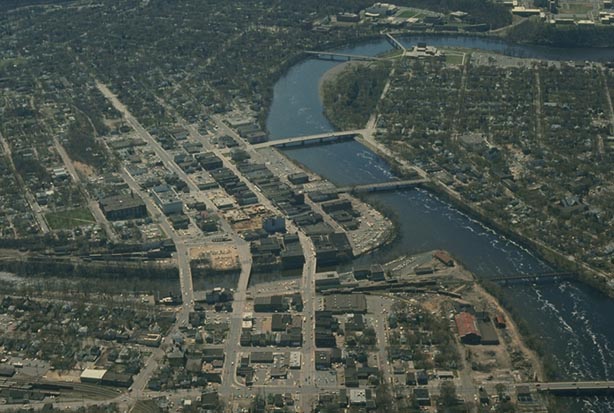
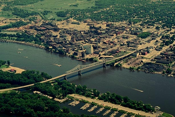
EAU CLAIRE
Eau Claire, Eau Claire County. April 24, 1974. Altitude c. 3,500 ft. A major portion of the Eau Claire central business district is at center in this view to the southeast. The Chippewa River enters the scene at lower right, making a prominent meander before it exits at upper right. Six bridges span the Chippewa within this photograph. A tributary of the Chippewa, the Eau Claire River, cuts from left to right at bottom center to meet the larger stream. Three bridges span the Eau Claire. Residential neighborhoods constitute much of the remaining land. A major portion of the University of Wisconsin-Eau Claire campus is seen at extreme upper right.

A SWARM OF DRUMLINS
Waterloo and Marshall, Jefferson and Dane Counties. February, 1970. Altitude c. 5,000 ft. The snow cover of this winter scene highlights a swarm of drumlins. Slopes of many of these parallel hills are wooded, in contrast to the surrounding cropped and pastured farmland. The drumlins were deposited by the Green Bay Lobe of the Wisconsin Glacier about 20,000 years ago as it moved to the southwest (left bottom of frame).
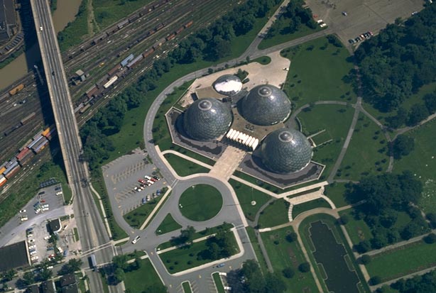
MITCHELL PARK DOMES
Milwaukee, Milwaukee County. July, 1968. Altitude c. 1,500 ft. The three domes of the Mitchell Park Conservatory are centered in this low oblique photograph to the north. The brown-colored Menomonee River makes a northward bend at top left, and the Layton Avenue (Highway 57, 27th Street) viaduct crosses the river valley and railroad tracks, also at left. The domes house rainforest, desert, and seasonal botanical exhibits.

DEVILS LAKE
Baraboo, Sauk County. August, 1966. Altitude c. 6,500 feet. Devils Lake, its surrounding quartzite bluffs, and the city of Baraboo are all seen in this view to the NNW. Motorboats, now forbidden under current park regulations, are prominently featured on the lake’s surface. The south campground, now converted to a picnic area, is at bottom right. The east and west bluffs are approximately 500 feet high above the surface of the lake.
DE SOTO
De Soto, Vernon County. Aug. 24,1974. Altitude c. 1,000 ft. The community of De Soto is seen in a high oblique view to the northeastern horizon from a position over the Mississippi River. It is located on a terrace of the river and extends part way up a prominent valley into the plateau-like uplands east of the Mississippi. Highway 82 follows the valley away from the observer. Steep bluffs rise abruptly from the valley sides. The cooler and more moist north-facing slopes on the right side of the valley support denser woodland cover than the drier south-facing slopes at left.
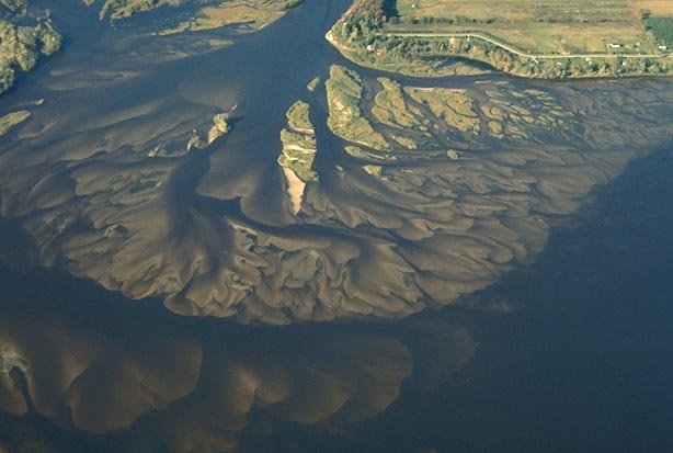
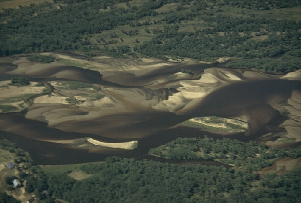
DELTAIC COMPLEX
Plainville, Adams County. October 2, 1975. Altitude c. 2,500 ft. Sand islands and submerged sand bars are components of a deltaic complex which extends out into the main channel of the Wisconsin River at the south end of Clark Island, about seven miles north of Wisconsin Dells. The pattern not only is a good example of geomorphologic process and form but also presents a natural artwork.

WISCONSIN DELLS
Wisconsin Dells, Columbia and Sauk Counties. August, 1966. Altitude 7,500 ft. This view to the NNE reveals the city of Wisconsin Dells at right center, a portion of the Lower Dells of the Wisconsin River at lower right, and the Upper Dells at upper center. Highway 13 angles across the upper right. The Upper Dells, a narrow gorge as little as 100 feet in width in places, was created when the waters of Glacial Lake Wisconsin cut a new channel through weak Cambrian Sandstone here about 14,000 years ago as it emptied southwestward into the lower Wisconsin and Mississippi Rivers. The communities of Wisconsin Dells and adjacent Lake Delton (lower left) appear relatively undeveloped in this 1966 photograph, but today numerous amusement parks and recreational businesses make it the prime tourist- oriented locale in Wisconsin.

CRANBERRY BOGS
Warrens, Monroe County. July, 1959. Altitude c. 5,000 feet. Several large cranberry bogs are highlighted by the white sand of dikes and roads. Some small lakes, extensive marshland, and a few areas of trees occupy the major portion of this verdant landscape, once beneath the waters of Glacial Lake Wisconsin. This is the state’s primary cranberry-producing locality. Wisconsin and Massachusetts vie for the top position among the states in cranberry output.
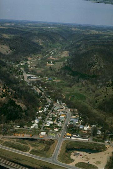
COON VALLEY
Coon Valley, Vernon County. Sept., 1970. Altitude c. 2,000 ft. The village of Coon Valley is located in a broad valley surrounded by wooded ridge slopes in this view to the WNW. The scene is an excellent example of the topography of the unglaciated Western Upland. Accordant summits of ridges create an almost level horizon in this high oblique perspective.

CIRCUS WORLD MUSEUM
Baraboo, Sauk County. July, 1967. Altitude c. 1,500 feet. The Circus World Museum’s brightly colored buildings appear on both banks of the Baraboo River in this view toward the northeast.
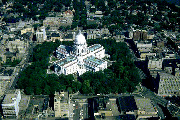
WISCONSIN STATE CAPITOL
Madison, Dane County. July, 1965. Altitude c. 2,500 feet. The newly-cleaned granite surface of the State Capitol building gleams white in the sun in contrast with its green copper roofs in this view of Capitol Square. The perspective also includes surrounding streets and businesses.
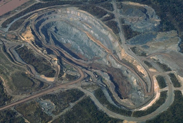
OPEN PIT MINE
Black River Falls, Jackson County. 1982. c. 3,500 ft. The entire open pit mine of the Inland Steel Corporation operation is in view. Precambrian magnetite, overlain by a thin Cambrian sandstone layer, was extracted here from the late 1960s to the early 1980s. Although iron deposits still remain at this site, declining demand for ore resulted in the subsequent closing of the mine. In the early 1990s, about ten years after this photograph was made, the State of Wisconsin allowed ground water levels to rise in the former mine to create Lake Wazee, now the deepest inland body of water in the state with a depth of 350 feet.

BREWERY CREEK
Mineral Point, Iowa County. August, 1970. Altitude c. 2,000 ft. The rusty-red waters of Brewery Creek stand out in sharp contrast to green trees and cropland just south of the community of Mineral Point where lead and zinc mining and smelting, once an important economic activity, is now all but history. The curving white road to the right is Ferndale Road, and the straight path to the left of the stream is the Central Wisconsin railroad. This photograph is virtually vertical in perspective; northwest is to the top.
Dean Connors of the Mineral Point Historical Society writes that the source of the red waters was from the huge Mineral Point Zinc Plant, one of the largest in the world. Local ores contained practically no non-zinc contaminates, but when the zinc plant started importing Western and Mexican ores to process, considerable iron and other metallic contaminants were imported. It was the iron discarded in the “roasting” process that created the stunning red color in Brewery Creek as it flowed past the roaster discard pile. In the early 1990’s the DNR moved the roaster discard material farther south, and the color of the water has pretty much returned to normal.

BLUE MOUND
Blue Mound, Dane County. Aug., 1970. Altitude c. 1,000 ft. Blue Mound rises above the surrounding countryside in this almost horizontal view toward the northern horizon. Its flat top, capped by Niagaran Dolomite, is 1716 feet above sea level, making it the highest point in southern Wisconsin. Local relief from base to top is 415 feet. Its wooded slopes are green in this view from approximately four miles distance. Higher land which comprises the far horizon beyond Blue Mound is probably the Baraboo Range at a distance of approximately twenty miles. Blue Mound is the largest of Wisconsin’s dolomitic outliers, a landform similar to the mesas of the western US.

BEEF OPERATION
Mt. Horeb, Dane County. August, 1970. Altitude c. 1,000 ft. A beef farm with its ensemble of buildings and silos is seen in low oblique. Several pole barns and six silos, four of which are blue Harvestores, are evident. Cattle are not visible.
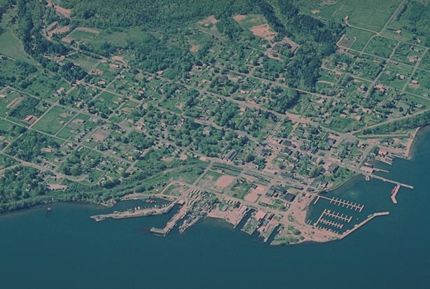
BAYFIELD
Bayfield, Bayfield County. June, 1970. Altitude c. 3,000 ft. The entire city of Bayfield is centered in a low oblique perspective to the northwest. The blue-green waters of North Channel are to the southeast (bottom) of the city. North Channel separates the Bayfield Penninsula from Madeline Island, the largest of the Apostle Island group. The city’s business district is identifiable at right center. A marina, built for recreational craft, is enclosed by a small breakwater at lower right. Several docks, the largest of which accomodates the Madeline Island ferry, is at lower center.
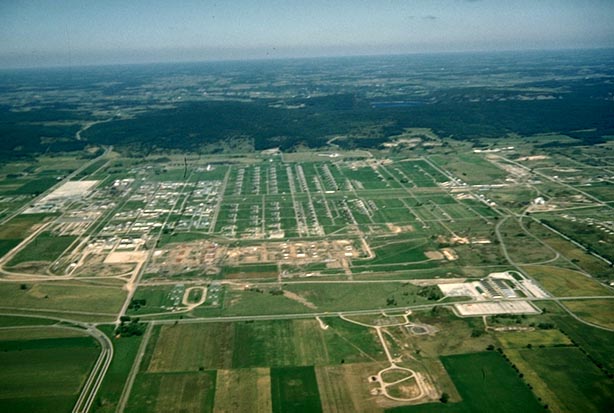
BADGER ORDNANCE
Baraboo, Sauk County. September 21, 1954. Altitude c. 3,500 ft. The Badger Ordnance Works, a maker of munitions for the US military, is situated on a plain south of the east-west trending South Range of the Baraboo Range (middle distance). The view is toward the north. US Highway 12 is to the left. Devils Lake can be seen occupying a gap in the South Range (right of center). The operation is now defunct.
ASHLAND
Ashland; Ashland and Bayfield Counties. June 5, 1951. Altitude 5,000 ft. This view to the north shows the city of Ashland with several iron ore docks which project into Chequamegon Bay. In the middle distance is the Bayfield Peninsula; in the far distance are the open waters of Lake Superior. Several of the Apostle Islands appear at upper right, under the wing strut. Reddish clays in suspension muddy the waters of the bay.
APPLE ORCHARD
Egg Harbor, Door County. August, 1966. Altitude c. 1,000 ft. Fruit orchards occupy a large portion of this rolling landscape near the community of Egg Harbor. The orchard headquarters is at lower left. A large white building advertises this operation as “Eames Orchard”. Tart cherries and apples are grown along the Door County Peninsula because of the moderating and modifying effects of Green Bay and Lake Michigan which reduce the danger of frost damage to the blossoms and fruit.
ANIMALS!
Sparta, Monroe County. July, 1969. Altitude c. 1,000 ft. A small factory manufactures large fiberglass objects and animals for outdoor advertising. Pigs, various breeds of cattle, buffalo, hot dog in a bun, roast turkey, chicken, and a bottle of ketchup are visible. Their large size can be judged relative to nearby cars and people. This industry markets its products nationally.

ALEXIAN BROTHERS NOVITIATE
Gresham, Shawano County. October 20, 1975. Altitude c. 2,000 ft. The camera looks SSW to the former Alexian Brothers Novitiate, situated on the north bank of the Red River about two miles east of Gresham and one-half mile south of the Menominee (County) Indian Reservation. On New Year’s eve, 1974, a group called the Menominee Warrior Society took control of the vacant Roman Catholic facility, claiming it for Menominee tribal use as a hospital. In a well-publicized confrontation with the Wisconsin National Guard, the demonstrators were forced to withdraw, leaving the building in a state of disrepair.