By Ethan Lockwood
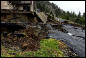
Tillamook County may be best known for its trees, cheese, and ocean breeze–but it also home to significant natural hazards. The county’s stunningly beautiful coastline has long attracted housing and development that takes advantage of the gorgeous views, remote settings, and remarkable topography. Yet, natural hazards are also an inescapable reality of the Oregon coast.
Landslides, coastal erosion, tsunamis, and dune migration pose serious risk to coastal development. The county has a long history of natural hazard events, coastal erosion and landslides in particular, that have caused significant damage to infrastructure and property while posing a safety risk to residents. Mitigating the risk of natural hazards to new development is a current priority of the county. To help achieve this, graduate students in the Community Planning Workshop are developing a toolbox of regulatory and non-regulatory natural hazard mitigation approaches for the county.

Development codes are a tool used by communities and counties to regulate where what type of development can occur. Diverse and ongoing natural hazard planning has occurred throughout the county detailing the severity and location of natural hazard risk, but stronger incorporation of this information into the County Development Code is needed to best protect future development. From geological site reports and safest building site selection to dune vegetation protection to prevent erosion, a diversity of regulations and tools are under consideration.
Through the creation of development code case studies and research on best practices, this graduate student team lead by Michael Howard, Assistant Program Director of the Community Service Center, will help to ensure that the trees, cheese, and ocean breeze of Tillamook County can be safely enjoyed for years to come.
This project is funded through a Federal Emergency Management Agency (FEMA) grant. The University of Oregon’s Community Service Center’s (CSC) Oregon Partnership for Disaster Resilience (OPDR) was invited by FEMA to become a Cooperating Technical Partner under the FEMA Risk MAP program. This project is occurring with cooperation and consultation with Tillamook County staff, Planning Commission, and the Board of County Commissioners (BOCC).
Ethan Lockwood is pursuing a masters in Community and Regional Planning at the University of Oregon. While not studying open space, parks, and land preservation he can be found on the local singletrack trails hiking, running, and skiing as much as grad school allows.
