I consider myself a broadly-minded geographer with an interest in human-environment interactions, as well as the methods and philosophies of geographic research. Within those areas, my research and scholarly activities fall in two major areas: biophysical geography and geographic information science. I am particularly interested in the making of river and mountain places and spaces from both a spatial and a systematic point of view. I am also interested in the concept of habitat. My secondary interests in river studies include water law and management as well as river restoration.
I help coordinate the University of Oregon River Research Group, and I collaborate with other groups including the Environmental Change Research Group, the S3C Lab, and the Earth Surface Processes Laboratory.
River Remote Sensing from millimeter scales to global scales
Over the past decade or so my students and I have worked to develop methods to map river environments at many scales and resolutions using a variety of techniques. These methods include algorithm development for the upcoming NASA SWOT satellite (a large radar interferometer which will map the world’s surface water beginning in 2020), airplane-based imaging of river habitats using spectral information in color imagery, and new photogrammetric reconstructions of river environments using simple cameras on inexpensive platforms such as poles, remote controlled craft, balloons, and kites. The main photogrammetric approach I use is “Structure from Motion” (SfM). Two video examples of this type of reconstruction are below:
Salmon River, Oregon imaging flight and photogrammetric reconstruction with Christina Shintani
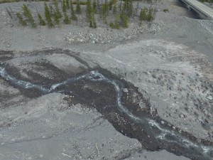
White River, Oregon imaging flight and photogrammetric reconstruction with Aaron Zettler-Mann
White River below Mt. Hood, Oregon.
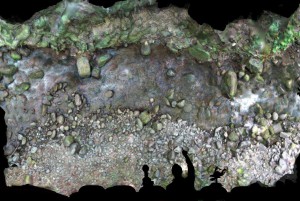
Scott Creek, McKenzie River basin
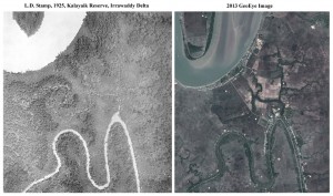
Remote sensing need not be high-tech or super expensive to be useful in understanding river functioning. A great deal can be gleaned from historical aerial photos and also from repeat ground photography. Below is an example of river change detection based on comparing modern imagery (2013) with aerial imaging — this example is from the Irrawaddy River delta and the original image was taken by an academic great-grandfather of mine, L. Dudley Stamp in 1925.
Areas where I have been involved in river remote sensing projects include the Willamette River (OR), the Middle Fork John Day River (OR), Yellowstone National Park (WY/MT), Scott Creek (OR), River Tromie, Scotland (UK), Brazos River (TX), Pedernales River, and the Nueces River (TX).
The Natural and Human Spatial Structuring of Riverscapes
While I spend a lot of time worrying about river measurement issues, I am fundamentally more interested in theoretical and applied questions about riverscape structuring, much as my doctoral advisor Will Graf has been. To that end, I have used a variety of theoretical and empirical analyses to try to understand why river environments are patterned the way they are, and what various external processes (natural and human) due to these patternings. My early work on these structurings were in high mountain streams in the Sangre de Cristo Mountains (NM/CO) and in Yellowstone National Park. More recently I have begun to focus on the Willamette riverscape, a large region in western Oregon along which most of the population of Oregon resides.
Areas where I have been involved in theoretical and applied work involving the spatial structuring of riverscapes (beyond river remote sensing projects) include the Willamette River (OR), Yellowstone Natiional Park (WY), River Tromie, Scotland (UK), Costilla River basin (NM/CO), and Canyon Lake Gorge (TX).
Current Projects
Dynamics of Large River Channel Change, Willamette River, Oregon
This research centers on the historical changes in Willamette River morphology, sediment transport, hydraulics and hydrology, and the interactions of these with near-channel riparian and floodplain areas. One of the goals is to understand the geomorphic effects of management strategies on the river, such as dam operations and channel bank armoring. Techniques include aerial imagery and Lidar-based analysis, sediment measurements on channel bars, modeling of hydraulics and sediment transport, and remote-sensing and sonar-based bathymetric mapping.
Mountain Stream Dynamics and Mapping Techniques Development, Scott Creek and White River Basins, Oregon
These projects focus on understanding the development of channel geometry and habitats in a high energy, High Cascade stream environments. To measure the stream channels longitudinally in such an extremely complex environment, new mapping techniques based on ground-based structure from motion and Kinect structured light mapping are being developed and tested. A combination of centimeter-scale mapping and agent-based modeling approaches will allow digital stream ecosystem simulation at the organism scale.
Co-Edited Volumes
Rhoads, B.L. and Fonstad, M.A. 2015. The Natural and Human Structuring of Rivers and
other Geomorphic Systems. Special Edited Volume of Geomorphology.
Fonstad, M.A. 2013. Geographies of Water: Special Issue of the Annals of the Association of American Geographers, vol. 103, no.2, 16 papers printed + 1 introduction.
Marcus, W.A. and Fonstad, M.A. 2010. Remote Sensing of Rivers: Special Edited Volume of Earth Surface Processes and Landforms. 17 papers printed + 1 preface.
Murray, A.B. and Fonstad, M.A. 2007. Complexity in Geomorphology: Proceedings of the 38th International Binghamton Geomorphology Symposium. Amsterdam: Elsevier. 407 pp. ISSN 01669-555x.
Publications List and associated Abstracts (Peer-Reviewed)
Courville, B., Jensen, J.L., Dixon, R., Fonstad, M.A. 2014. A Landsat-based evaluation of lake water clarity in Maine lakes. Physical Geography, vol. 35, no. 4, pp. 355-368.
Fonstad, M.A., Dietrich, J.T., Courville, B.C., Jensen, J.L., Carbonneau, P.E. 2013. Topographic structure from motion: a new development in photogrammetric measurement. Earth Surface Processes and Landforms, vol. 38, no. 4, pp. 421-430.
Fonstad, M.A. Cellular automata in geomorphology. 2013. Chapter 2.9, pp. 117-134 in the Volume 2 (Andreas Baas, editor) of the Treatise in Geomorphology series, edited by John F. Shroder..
Fonstad, M.A. 2012. Hyperspectral imagery in fluvial environments. Chapter 4, pp. 71-84 in Remote Sensing of Rivers: Management and Implications, Carbonneau, P. and Piegay, H. (eds).
Legleiter, C.J., Fonstad, M.A. 2012. An introduction to the physical basis for deriving river information by optical remote sensing. Chapter 3, pp. 43-69 in Remote Sensing of Rivers: Management and Implications, Carbonneau, P. and Piegay, H. (eds).
Marcus, W.A., Fonstad, M.A., and Legleiter, C.J. 2012. Management implications of optical remote sensing in the active river channel. Chapter 2, pp. 19-41 in Remote Sensing of Rivers: Management and Implications, Carbonneau, P. and Piegay, H. (eds).
Carbonneau, P., Fonstad, M.A., Marcus, W.A., Dugdale, S. Making Riverscapes Real. 2012. Geomorphology, vol. 137, no. 1, pp. 74-86.
Walther, S., Marcus, W.A., Fonstad, M.A. 2011. Evaluation of high-resolution, true-colour, aerial imagery for mapping bathymetry in a clear-water river without ground-based depth measurements. International Journal of Remote Sensing, vol. 32, no. 15, pp. 4343-4363.
Marcus, W.A., Rasmussen, J., Fonstad, M.A. 2011. Fire and flood effects on local to watershed scale distributions of large wood in Yellowstone streams. Annals of the Association of American Geographers. Vol. 101, no. 1, pp. 21-44.
Lamb, M.P. and Fonstad, M.A. 2010. Rapid formation of a modern bedrock canyon: implications for megaflood reconstructions. Nature Geosciences, vol. 3, no. 7, pp. 477-481.
Fonstad, M.A. and Marcus, W.A. 2010. High-resolution, basin-extent observations of fluvial forms and implications for process understanding. Earth Surface Processes and Landforms, vol. 35, pp. 680-698.
Murray, A.B. Lazarus, E., Ashton, A., Baas, A., Coco, G., Coulthard, T., Fonstad, M., Haff, P., McNamara, D., Paola, C., Pelletier, J., Reinhardt, L., 2009, Geomorphology, complexity, and the emerging science of the earth’s surface. Geomorphology. vol. 103, pp. 496-505.
Resler, L.M. and Fonstad, M.A., 2009. A Markov analysis of fine scale change at alpine treeline, in The Changing Alpine Treeline in Glacier National Park, Montana, USA. Butler, D., Malanson, G., Walsh,S., Fagre, D. (eds).
Marcus, W.A. and Fonstad, M.A., 2008, Optical remote mapping of rivers at sub-meter resolutions and watershed extents, Earth Surface Processes and Landforms, vol. 33, pp. 4-24.
Giordano, A., Lu, Y., Anderson, S.A., Fonstad, M.A., 2007, Wireless mapping, GIS, and learning about the digital divide: a classroom experience, Journal of Geography, vol. 106, pp. 285-295.
Parsons, J.A. and Fonstad, M.A., 2007, A geographical cellular automata model of surface water flow, Hydrological Processes, vol. 21, no. 16, pp. 2189-2195.
Fonstad, M.A., 2006, Cellular automata as analysis and synthesis engines at the geomorphology-ecology interface, Geomorphology, vol. 77, no. 3-4, pp. 217-234.
Conyers, M.M. and Fonstad, M.A., 2005, The unusual channel resistance of the Texas Hill Country and its effect on flood flow predictions, Physical Geography, vol. 26, no. 5, pp. 370-395.
Fonstad, M.A. and Marcus, W.A., 2005, Remote sensing of stream depths with hydraulically-assisted bathymetry (HAB) models, Geomorphology, vol. 72, no. 4, pp. 320-339.
Dunham, S., Fonstad, M.A., Anderson, S.A., Czajkowski, K., 2005, Using multi-temporal satellite imagery to monitor the response of vegetation to drought in the Great Lakes region, GIScience and Remote Sensing, vol. 42, no. 3, pp. 185-201.
Jordan, D.C. and Fonstad, M.A., 2005, Two-dimensional mapping of river bathymetry and power using aerial photography and GIS on the Brazos River, Texas, Geocarto International, vol 20, no. 3. pp. 1-8.
Fonstad, M.A., Reichling, J., Van de Grift, J.W., 2005, Design of a new transparent velocity head rod for rapid and precise stream velocity measurements, Journal of Geoscience Education, vol. 53, no. 1, pp. 44-52.
Legleiter, C.J., Roberts, D.A., Marcus, W.A., Fonstad, M.A., 2004, Optical remote sensing of river channel morphology and in-stream habitat: physical basis and feasibility, Remote Sensing of Environment, vol. 93, pp. 493-510.
Fonstad, M.A. and Marcus, W.A., 2003, Self-organized criticality in riverbank systems, Annals of the Association of American Geographers, vol. 93, no. 2, pp. 281-296.
Legleiter, C.J., Lawrence, R.L., Fonstad, M.A., Marcus, W.A., Aspinall, R., 2003, Fluvial response to wildfire in northern Yellowstone: a spatially explicit analysis, Geomorphology, vol. 54, no. 3-4, pp. 119-136.
Resler, L.M., Fonstad, M.A., Butler, D.R., 2003, Mapping the alpine treeline ecotone with digital aerial photography and textural analysis, Geocarto International, vol. 19, no. 1, pp. 37-44.
Fonstad, M.A., 2003, Spatial variation in the power of mountain streams in the Sangre de Cristo Mountains, USA, Geomorphology, vol. 55, no. 1-4, pp. 75-96.


